Search results
Jump to navigation
Jump to search
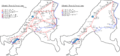
File:Gfw map railway network 1950 and 2018 with terminal stations marked.png Maps showing the extent of the railway and ferry line network in Gfiewistan in 1 ...tan]] [[Category:Railway maps]] [[Category:Transport by water]] [[Category:Transport in Gfiewistan]](1,834 × 858 (219 KB)) - 11:32, 12 July 2021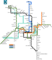
File:Cherrinmetromap.png ...optemia]][[Category:Transport by rail]][[Category:railway maps]][[Category:Maps of Soltenna]](2,000 × 2,279 (426 KB)) - 20:16, 12 November 2022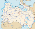
File:Lhavres Infrastructure.png [[Category:Maps of Lhavres]] [[Category:Transport maps]](1,324 × 1,108 (131 KB)) - 10:57, 18 April 2022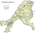
File:Gfw map districts with railways, stations and ferry line stations.png ...tan]] [[Category:Railway maps]] [[Category:Transport by water]] [[Category:Transport in Gfiewistan]](950 × 888 (181 KB)) - 11:34, 12 July 2021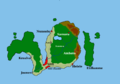
File:Jute map bigger changed terrain labeled improved colors with railways.png [[Category:Railway maps]] [[Category:Maps of Jute]] [[Category:Transport in Jute]](1,512 × 1,060 (169 KB)) - 11:40, 12 July 2021
File:Sitti railway.png [[Category:Railway maps]] [[Category:Transport in Jute]] [[Category:Maps of Jute]](800 × 600 (61 KB)) - 11:38, 12 July 2021- [[Category:Maps]][[Category:Transport by rail]]9 members (0 subcategories, 9 files) - 19:38, 18 January 2021
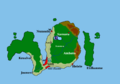
File:Jute map bigger changed terrain labeled improved colors again with railways and airfields.png [[Category:Maps of Jute]] [[Category:Transport in Jute]] [[Category:Airports]](1,512 × 1,060 (175 KB)) - 11:40, 12 July 2021- <!-- *** Maps *** --> ==Transport==10 KB (1,205 words) - 19:15, 30 May 2024
- ...ly administered by the diarchy, but are not marked as such on Haisearelian maps, instead appearing as its own district in the case of Iſtinkír, split bet ===Transport===11 KB (1,547 words) - 15:18, 31 May 2024
- ...TC|}}} |<span class="nowrap">[[Transport Canada|TC]] [[Location identifier#Transport Canada identifier|LID]]: <span class="nickname">{{{TC}}}</span></span>}} |11|111=Maps}}14 KB (1,511 words) - 20:43, 3 November 2020
- |map_caption = Locator maps <!--Caption to place below map--> ===Transport===13 KB (1,913 words) - 23:45, 7 July 2022
- : The three or four character [[Transport Canada]] [[location identifier]] for airports in Canada. If omitted or left ...|pushpin map]] with an automatically-placed airport icon and label (see [[#Maps|below]]).53 KB (6,911 words) - 20:34, 6 April 2021
- ...same familiar themes. Rivers, due to their importance for e.g. irrigation, transport and a source of food came to be seen as the natural mothers of the country ...eir focus entirely towards the latter two becoming known as "dark stores". Maps purporting to lead to sites mentioned in these modern myths are nowadays al9 KB (1,378 words) - 12:54, 1 October 2023
- |<code>coords_type</code> || Type is one way to specify the scale of maps generated by external map websites. See [[WP:COORD TYPE|type]] for valid va |<code>publictransit</code> || The nearest public transport stop.20 KB (2,943 words) - 20:04, 15 June 2016


