Difference between revisions of "Šoasal"
Jump to navigation
Jump to search
m (→Etymology) |
m |
||
| Line 267: | Line 267: | ||
[[Category:Settlements]] | [[Category:Settlements]] | ||
[[Category:Akamyokultan settlements]] | |||
Revision as of 09:25, 30 September 2020
Shoasal
śоasal | |
|---|---|
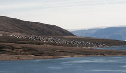
 A view on Šoasal from sea | |
| Nickname(s): Šas | |
| Country | |
| Region | Eastern Islands Region |
| Municipality | Ŋeivlaš |
| Area | |
| • Total | 3.1 km2 (1.2 sq mi) |
| Elevation | 3 m (10 ft) |
| Population (2015) | |
| • Total | 295 |
| • Density | 95/km2 (250/sq mi) |
| Postal code | 701 |
Šoasal (Niryokulta: [ˈɕoa̯.sal]) is the capital of Ŋeivlaš municipality located on the Ŋohšagám island. It is the northernmost settlement of Akamyokulta. It was first settled in late 20s of 20th century.
Etymology
The name Šoasal literally means "northern village" (šoa(l)- "north" + -sal "village affix").
History
Geography
Climate
Šoasal has arctic climate (Köppen classification ET).
| Climate data for Šoasal | |||||||||||||
|---|---|---|---|---|---|---|---|---|---|---|---|---|---|
| Month | Jan | Feb | Mar | Apr | May | Jun | Jul | Aug | Sep | Oct | Nov | Dec | Year |
| Record high °C (°F) | 0.2 (32.4) |
1.3 (34.3) |
4.8 (40.6) |
5.9 (42.6) |
8.4 (47.1) |
11.7 (53.1) |
16.4 (61.5) |
13.6 (56.5) |
10.9 (51.6) |
7.7 (45.9) |
4.2 (39.6) |
2.0 (35.6) |
16.4 (61.5) |
| Record low °C (°F) | −38.1 (−36.6) |
−34.3 (−29.7) |
−30.5 (−22.9) |
−22.1 (−7.8) |
−11.6 (11.1) |
−8.4 (16.9) |
−3.5 (25.7) |
−6.7 (19.9) |
−10.8 (12.6) |
−24.2 (−11.6) |
−35.3 (−31.5) |
−37.4 (−35.3) |
−38.1 (−36.6) |
| Mean monthly sunshine hours | 0.0 | 0.0 | 70.2 | 172.9 | 191.5 | 163.3 | 146.1 | 110.4 | 68.7 | 11.1 | 0.0 | 0.0 | 934.2 |
| Source: Yokultan Meteorological Institute | |||||||||||||