Difference between revisions of "Archive:Dulozud"
| Line 45: | Line 45: | ||
<br /> | <br /> | ||
2.87% [[Adzamasiin]] | 2.87% [[Adzamasiin]] | ||
12.26% Other <!--List/breakdown of ethnic groups within the country/territory--> | |||
|ethnic_groups_year = 2020 census <!--Year of ethnic groups data (if provided) or use to place a <ref>--> | |ethnic_groups_year = 2020 census <!--Year of ethnic groups data (if provided) or use to place a <ref>--> | ||
|demonym = Dulozi <!--Term/s describing those associated with the country/territory (e.g. "Belgian" for the country Belgium)--> | |demonym = Dulozi <!--Term/s describing those associated with the country/territory (e.g. "Belgian" for the country Belgium)--> | ||
Revision as of 15:16, 15 June 2020
| United Kingdom of Dulozud Duylozuhd |
||||
|---|---|---|---|---|
|
||||
| Motto: Something | ||||
| Anthem: Something Royal anthem: Something |
||||
| Capital and | Guzodubez | |||
| Official languages | Tulsan | |||
| Ethnic groups (2020 census) | 60.78% Dulozi
9.3% Mbaku
|
|||
| Demonym | Dulozi | |||
| Government | ||||
| - | King | Dude IneedAnameForHim | ||
| Population | ||||
| - | 2020 estimate | 6,851,000 | ||
| Drives on the | right | |||
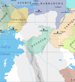
Country (Language: Dulozud [dujlozuʰd]), officially the United Kingdom of Dulozud, is a country located in central Baredina. Dulozud is ...
Etymology
History
Geography
(need to redo a bit)
The land area of the Kingdom of Dulozud is approximately ####### sqaure kilometers. The country is split into four main regions: the Ekuos River region, the NAME Desert, the NAME Mountains, and the NAME Coasts. (more intro plz)
The Name Coasts is a geographical region with a Hot-Summer Mediterranean climate that ranges in elevation from 500 meters to sea level. The region can be further divided into the Lowland Coastal Subregion and the Foothill Subregion. The Coastal Subregion is a wide coastal plain vegetated by grasses, shrubs, sub-shrubs, herbs, and sparse patches of conifers and fruit trees. Some of the most fertile land in the country is located in the lowlands; many rivers and streams bring down sediments and nutrients from the foothill subregion. Grasses, shrubs, herbs, and sparse patches of conifers and fruit trees vegetate the land. The foothills average at around 250 to 500 meters in elevation. Shrubs make up over 65% of the vegetation in the foothills, with evergreen, deciduous, and fruit trees making up the rest. Average temperatures during the warmest month is around 22°C and during the coldest between 18 and -3°C. Hot-Summer Mediterranean climates are characterized by having dry summers and mild, wet winters.
The NAME Mountains is a geographical region (rewrite intro)… (cold desert, cold semi-arad, hot desert)
The NAME Desert is a… (hot desert, cold desert)
The geographical region surrounding the Ekuos river… (hot desert)
Geology
Climate
Hot Desert, Cold Semi-Arad, Cold Desert, Hot-Summer Mediterranean
Biodiversity
Politics
Government
Administrative divisions
split into a few kingdoms that are further split into provinces
Foreign relations
Military
Economy
Transport
in the cities mostly car and train. The rest of the country uses car, train, plane. Maybe have a train network across the country.
Energy
solar, wind, coal. There are massive solar farms
Science and technology
Tourism
not really touristy
Demographics
Ethnic groups
Urbanisation
Language
Education
Healthcare
Religion
mostly tanhunga

