Difference between revisions of "Archive:Ymyölin River"
| Line 37: | Line 37: | ||
| mouth_elevation = | | mouth_elevation = | ||
| altitude_difference= | | altitude_difference= | ||
| basin_size = | | basin_size = 4 030 000 km² | ||
| basin_countries = {{flag|Eliposi}}<br>{{flag|Temay}}<br>{{flag|Uvanga}}<br>{{flag|Garelsjema}}<br>Dyaron<br> | | basin_countries = {{flag|Eliposi}}<br>{{flag|Temay}}<br>{{flag|Uvanga}}<br>{{flag|Garelsjema}}<br>Dyaron<br> | ||
| basin_cities = | | basin_cities = | ||
| Line 66: | Line 66: | ||
}} | }} | ||
The '''Ymyölin River''' (''Matriarch River'', [[Thuun]] pronunciation: | The '''Ymyölin River''' (''Matriarch River'', [[Thuun]] pronunciation: /ˈymyø̯:lin/), also known as the '''Sahgkyuvö River''' (''Queen River'', [[Elipa]] pronunciation: /sɐ:gʲʉvø/) is a great river in northern and central [[Mahavia]]. At around 4845 kilometres, it is one of the longest rivers in the world, and forms a natural border between [[Temay]] and [[Eliposi]]. | ||
Ymyölin's watershed area covers most of [[Uvanga]], where it is of great cultural and economic importance. | Ymyölin's watershed area covers most of [[Uvanga]], where it is of great cultural and economic importance. The river serves as a crucial ice-road in the winter, linking otherwise isolated communities. Riverboat tours in the summer also provide Uvanga's most significant tourist attraction. | ||
==Etymology== | ==Etymology== | ||
Revision as of 00:00, 24 April 2017
| Ymyölin River Matriarch River | |
|---|---|
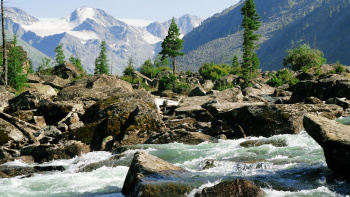
 Section of the river flowing through the mountains on the border between Temay and Eliposi | |
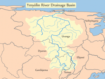
 Ymyölin's drainage area | |
| Native name | Ymyölin Joa / Joalun Ymyölin |
| Other name(s) | Sahgkyuvö River |
| Basin | |
| Size | 4 030 000 km² |
| Countries | File:GRL Garelisian Flag.png Garelsjema Dyaron |
| Physiognomy | |
| Length | 4845 km |
The Ymyölin River (Matriarch River, Thuun pronunciation: /ˈymyø̯:lin/), also known as the Sahgkyuvö River (Queen River, Elipa pronunciation: /sɐ:gʲʉvø/) is a great river in northern and central Mahavia. At around 4845 kilometres, it is one of the longest rivers in the world, and forms a natural border between Temay and Eliposi.
Ymyölin's watershed area covers most of Uvanga, where it is of great cultural and economic importance. The river serves as a crucial ice-road in the winter, linking otherwise isolated communities. Riverboat tours in the summer also provide Uvanga's most significant tourist attraction.
Etymology
The Elipa name "Queen" (Sahgkya) comes from traditional Elipan folklore, in which this river was the Queen of the water spirits. It was also paired to the "King" river (Sahgheruvö).
The Thuun name "Matriarch" (Ymyölin) likely just refers to the river's large drainage area, known in Thuun as a "river family". Therefore the Ymyölin is the "river mother".
In other languages, it is known by...
History
Course
The Queen river begins in the mountains bordering Temay and Eliposi, flowing to the north through Dyaron and into Uvanga, where it eventually drains into the arctic.