Argeyaz Bay
| Argeyaz Bay | |
|---|---|
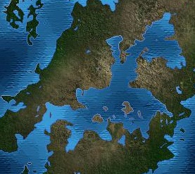
 Sattelite view of Argeyaz Bay (center) with the Taanttu Sea in the top left and the Gulf of Ishenar in the bottom right. | |
| Location | Western Ekuosia |
| Basin countries | Algazi Union, Fyevan, Orzunia, Saovia, Srojosia, Zhinayak |
| Max. width | 755 km (469 mi) |
| Surface area | 798,696 km2 (308,378 sq mi) |
| Shore length1 | 13,250 km (8,230 mi) |
| Islands | 10 |
| 1 Shore length is not a well-defined measure. | |
Argeyaz Bay (Algaz: Teg Argejað Teg Argeyaz, IPA: /teg aɾ.ge'jaz/, Hemeshi: oso orgejox, aža argejoþ Asa Argeyotz, IPA: /'ɑ.ʂɑ ɑɾ'ʁe.jot͡s/ )is a large bay or sea located between two peninsulas on the northwest coast of Baredina. The bay is connected to the Armizziya Sea through the Strait of Fyevan.
Argeyaz Bay has long played an important role for the populations and civilizations living around it, particularly for food and trade. It is also the origin of the Argeyazic language family, which bears its name.
Etymology
The bay is most widely known by its Algaz name Argeyaz, which in turn was likely borrowed from a neighboring Continental Argeyazic dialect. While the etymology is mostly unclear, it appears to have been derived in part from the Proto-Argeyazic word*argä, meaning mouth, likely in reference to the shape of the bay and the peninsulas on either side; this word is also the origin of the Hemeshi word for bay, as well as the name Algaz.
History
Prehistory and Early Civilization
Agriculture was introduced to the Argeyaz region some time after its emergence in in the Ekuos basin; consequently, early urban centers did not develop until much later.
At the beginning of the First Century CE, Argeyaz Bay took on greater importance in Ekuosian geopolitics. Following Letsatian expansion into the western part of the region, the Adzamasi Empire in turn sought to establish a presence in the bay through their local tributary state, the Hafsighi Kingdom. With Adzamsi support, the Hafsighi Kingdom established new ports along the Argeyaz coast and conquered existing ones.
Middle Ages
Sixteenth Century to Present
Geography
Argeyaz Bay can be divided into two portions: the larger Outer Argeyaz Bay, bordered by all surrounding countries, and the smaller Inner Argeyaz Bay, contained entirely within the Algazi Union. The Algazi city of Yazurum is generally considered to be the boundary between the two.
Islands
Climate
The climate of Argeyaz Bay and the surrounding region is dry and predominantly semi-arid, despite the proximity of much wetter regions along the Taanttu coast. On the other hand, the sea's moderating effects means that coastal areas, and often nearby inland ones, experience relatively mild temperatures, albeit warmer than those on the nearby coast of the Gulf of Ishenar.
Ecology
Modern Use
Argeyaz Bay remains a vital part of the regional economy. Several major shipping routes begin or end in Algazi and Hemeshi ports along the bay coast. Passenger travel is also still significant, particularly between cities around Inner Argeyaz Bay.