Difference between revisions of "Archive:Dapencher"
Jump to navigation
Jump to search
| Line 1: | Line 1: | ||
{{Infobox country | {{Infobox country | ||
|conventional_long_name = Penchic Federation | |conventional_long_name = Penchic Federation | ||
|native_name = Däpmhovče | |native_name = Däpmhovče | ||
|common_name = Dapencher | |common_name = Dapencher | ||
|image_flag = [[File: | |image_flag = [[File:Dap flag|thumbnail]] | ||
|alt_flag = <!--alt text for flag (text shown when pointer hovers over flag)--> | |alt_flag = <!--alt text for flag (text shown when pointer hovers over flag)--> | ||
|image_flag2 = <!--e.g. Second-flag of country.svg--> | |image_flag2 = <!--e.g. Second-flag of country.svg--> | ||
| Line 15: | Line 15: | ||
|other_symbol_type = <!--Use if a further symbol exists, e.g. hymn--> | |other_symbol_type = <!--Use if a further symbol exists, e.g. hymn--> | ||
|other_symbol = | |other_symbol = | ||
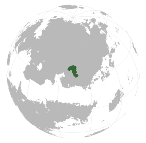
|image_map = | |image_map = [[File:Locator globe Dapencher.png|thumbnail]] | ||
|alt_map = <!--alt text for map--> | |alt_map = <!--alt text for map--> | ||
|map_caption = <!--Caption to place below map--> | |map_caption = <!--Caption to place below map--> | ||
Revision as of 19:11, 26 October 2018
| Penchic Federation Däpmhovče |
||||
|---|---|---|---|---|
|
||||
| [[File:|center|250px|alt=|]] | ||||
| Official languages | Foncrollian | |||
| Recognised regional languages | Atrish | |||
| Demonym | Pencher | |||
| Area | ||||
| - | 636 487.3 km2 245 749.12 sq mi |
|||
| Population | ||||
| - | 2015 estimate | 36 870 769 | ||
| Time zone | SCT +5 | |||
| - | Summer (DST) | not observed (SCT) | ||
| Drives on the | right | |||
| Calling code | +72 | |||
Dapencher (Foncrollian: Däpmhovče [IPA]), officially the Penchic Federation, is a country located in Western Parshita, bordering Jiihuhp, Hemberdoria and Thuutia. Dapencher is nearly exclusively of Rartakan origin with some enclaves of Cathani peoples.
