Dhwer and Penkrot
| United Kingdom of Dhwer and Penkrot Ðwer bem Penkrut |
||||||
|---|---|---|---|---|---|---|
|
||||||
| Motto: The Noble and the Common | ||||||
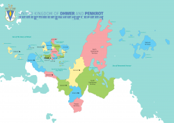
Map of Dhwer
|
||||||
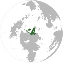
Location of the UKDP within Sahar
|
||||||
| Largest | KeHarl | |||||
| Government | ||||||
| - | King | Haym-Kalb II | ||||
| - | Premier | |||||
| Legislature | KaLenth | |||||
| - | Upper house | House of Nobles | ||||
| - | Lower house | House of the People | ||||
| Area | ||||||
| - | 1,450,400 km2 560,003 sq mi |
|||||
| Population | ||||||
| - | 2016 census | 110,422,300 | ||||
| - | Density | 76.13/km2 197.2/sq mi |
||||
| GDP (nominal) | estimate | |||||
| - | Total | 2,774,470,709,800 | ||||
| - | Per capita | 25,126 | ||||
| HDI (2015) | 0.5 low |
|||||
| Currency | Dhweran Yekt (DYT) | |||||
| Time zone | Central Boroso Time (SCT-3) | |||||
| - | Summer (DST) | not observed (SCT) | ||||
| Drives on the | right | |||||
| Calling code | +31 | |||||
| Internet TLD | .dh | |||||
The United Kingdom of Dhwer and Penkrot (IPA: //, Native language: Ðwer bem Penkrut, IPA: /ðweʁ bem peŋkrut̪/), commonly referred to as Dhwer or Dhwer and Penkrot (UKDP for short) is a country located in north-central Upper Boroso.
The UKDP is made up of two main parts, the Island of Dhwer and Penkrot, on the northern coast of the mainland of Boroso. The two parts are separated by the Haym-Kalb II Sea.
Penkrot is bordered on the southeast by Taanttu, to the south and west by Lhavres and to the south by the Vaamek and Kuthaltum. It shares a maritime border to the northwest with the Mbamigi Islandsand one to the southeast by Haraku.
Etymology
History
Between 1100 and 1700 CE the Great Dhwerian Empire ruled much of Northern and Central Upper Boroso.
Geography
Geology
Climate
Biodiversity
Politics
Government
Dhwer has a monarcho-communist government. While it is communist, it retained its royal family as figureheads and consultants to the government. This form of government is unique to Sahar.
Administrative divisions
Dhwer is divided into five main regions:
- Dhwer: The largest island, and most densely-populated populated region. Subdivided into 13 districts.
- Penkrot: The western half of the mainland. Subdivided into 6 district.
- Hayndwelp and Thyakw: The Eastern half of the mainland. Divided into 3 territories: North and South Hayndwelp and Thyakw.
- Thewer: A disputed territory with Vaamek which claims it as the state of Thewer.
- Overseas territories: Includes Dhweran Ekuosia, Dhweran Ystel, New KeHarl, and Thkelpenhurn.


