File:Herdek map.png
Revision as of 15:53, 25 November 2017 by Leonel2000 (talk | contribs) (A map showing Herdek's division in regions and their capitals, along with Herdek's capital and borders. Districtual borders and capitals were not added on this map for clearliness.)

Size of this preview: 600 × 600 pixels. Other resolutions: 2,048 × 2,048 pixels | 3,002 × 3,002 pixels.
Original file (3,002 × 3,002 pixels, file size: 1.8 MB, MIME type: image/png)
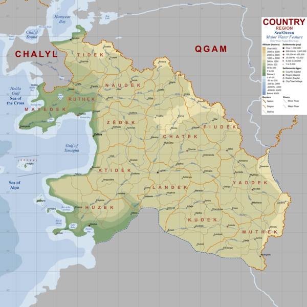
A map showing Herdek's division in regions and their capitals, along with Herdek's capital and borders. Districtual borders and capitals were not added on this map for clearliness.
File history
Click on a date/time to view the file as it appeared at that time.
| Date/Time | Thumbnail | Dimensions | User | Comment | |
|---|---|---|---|---|---|
| current | 21:08, 4 April 2018 | | 3,002 × 3,002 (1.8 MB) | Leonel2000 (talk | contribs) | |
| 21:08, 4 April 2018 |  | 3,002 × 3,002 (1.8 MB) | Leonel2000 (talk | contribs) | ||
| 21:07, 4 April 2018 |  | 966 × 926 (282 KB) | Leonel2000 (talk | contribs) | ||
| 13:57, 4 April 2018 |  | 3,002 × 3,002 (1.8 MB) | Leonel2000 (talk | contribs) | ||
| 15:53, 25 November 2017 |  | 966 × 926 (282 KB) | Leonel2000 (talk | contribs) | A map showing Herdek's division in regions and their capitals, along with Herdek's capital and borders. Districtual borders and capitals were not added on this map for clearliness. |
You cannot overwrite this file.
File usage
The following 2 pages use this file: