Difference between revisions of "Gêtuxur"
| Line 148: | Line 148: | ||
|year record high C= | |year record high C= | ||
<!-- Average high temperatures --> | <!-- Average high temperatures --> | ||
|Jan high C= | |Jan high C= 10.4 | ||
|Feb high C= | |Feb high C= 6.6 | ||
|Mar high C= -2. | |Mar high C= -2.3 | ||
|Apr high C= - | |Apr high C= -12.5 | ||
|May high C= -20.3 | |May high C= -20.3 | ||
|Jun high C= - | |Jun high C= -23.8 | ||
|Jul high C= -28.3 | |Jul high C= -28.3 | ||
|Aug high C= -26.9 | |Aug high C= -26.9 | ||
|Sep high C= - | |Sep high C= -22.0 | ||
|Oct high C= - | |Oct high C= -16.6 | ||
|Nov high C= - | |Nov high C= -4.8 | ||
|Dec high C= | |Dec high C= 5.1 | ||
|year high C= | |year high C= | ||
<!-- Mean daily temperature --> | <!-- Mean daily temperature --> | ||
| Line 176: | Line 176: | ||
|year mean C= | |year mean C= | ||
<!-- Average low temperatures --> | <!-- Average low temperatures --> | ||
|Jan low C= | |Jan low C= 4.1 | ||
|Feb low C= | |Feb low C= 2.0 | ||
|Mar low C= - | |Mar low C= -8.2 | ||
|Apr low C= - | |Apr low C= -18.0 | ||
|May low C= - | |May low C= -25.4 | ||
|Jun low C= - | |Jun low C= -30.7 | ||
|Jul low C= -35.9 | |Jul low C= -35.9 | ||
|Aug low C= -33.1 | |Aug low C= -33.1 | ||
|Sep low C= - | |Sep low C= -28.5 | ||
|Oct low C= - | |Oct low C= -21.3 | ||
|Nov low C= - | |Nov low C= -11.6 | ||
|Dec low C= | |Dec low C= 0.8 | ||
|year low C= | |year low C= | ||
<!-- Record low temperatures --> | <!-- Record low temperatures --> | ||
Revision as of 02:47, 13 September 2017
Geutuxur, Goetuxur
Gêtuxur | |
|---|---|
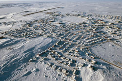
 Gêtuxur in the long winter months | |
| Elevation | 3 m (10 ft) |
| Population (2016) | |
| • Total | 20 782 |
| Demonym(s) | Vagêtuxur |
| Time zone | SCT+6 |
Gêtuxur (Atruozan: /gø.ty.k͡s̪yr/) is a city of approximately 20 000 people in soutern Translira, situated on the _____ Channel that separates the Unnsvlen Sea to the north, and the Chitsonawe sea to the south. It is the southernmost city above 20 000 people in the world, and the largest city in Translira's tundra regions. It serves as the capital and administrative center for the region of _____ and is the world's southernmost international port. Ethnically, the city is mostly Draklon, at around 85%, with the significant bulk of the remainder being Grenic. The majority language is Atruozan, with around 28% of the population speaking Texunel (a Draklon language mostly found in Osteria) as their mother tongue. Around 55% of the adult population (those above 16 years of age) is fluent in both languages, which are quite intelligable to one another, with an estimated 80% being able to hold a simple conversation in both. Gêtuxur experiences both the midnight sun in the summer and polar night in the wintertime. The city is headed by the leader of the Kajiléngès tribe, of which nearly all of the citizens of the city and surrounding areas are a part of.
Etymology
The name litterally means "big channel" or "great channel". It was named that due to its location on the large channel that separates the Unnsvlen Sea and the Chitsonawe sea.
History
Geography
Climate
| Climate data for Gêtuxur Airport 1965-present | |||||||||||||
|---|---|---|---|---|---|---|---|---|---|---|---|---|---|
| Month | Jan | Feb | Mar | Apr | May | Jun | Jul | Aug | Sep | Oct | Nov | Dec | Year |
| Average high °C (°F) | 10.4 (50.7) |
6.6 (43.9) |
−2.3 (27.9) |
−12.5 (9.5) |
−20.3 (−4.5) |
−23.8 (−10.8) |
−28.3 (−18.9) |
−26.9 (−16.4) |
−22.0 (−7.6) |
−16.6 (2.1) |
−4.8 (23.4) |
5.1 (41.2) |
−11.28 (11.71) |
| Average low °C (°F) | 4.1 (39.4) |
2.0 (35.6) |
−8.2 (17.2) |
−18.0 (−0.4) |
−25.4 (−13.7) |
−30.7 (−23.3) |
−35.9 (−32.6) |
−33.1 (−27.6) |
−28.5 (−19.3) |
−21.3 (−6.3) |
−11.6 (11.1) |
0.8 (33.4) |
−17.15 (1.12) |
| Source #1: [1] | |||||||||||||
| Source #2: [2] | |||||||||||||
Cityscape
Culture
Economy
Government
Demographics
International relations
- Pages with non-numeric formatnum arguments
- Redirects with short description
- Pages using infobox settlement with unknown parameters
- Pages using infobox settlement with missing country
- Pages using infobox settlement with no map
- Pages using infobox settlement with no coordinates
- Settlements
- CS1 errors: empty citation