Difference between revisions of "Archive:Iŋiqagáin archipelago"
Jump to navigation
Jump to search
m |
m |
||
| Line 107: | Line 107: | ||
[[Category:Islands]] | [[Category:Islands]] [[Category:Akamyokulta]] | ||
Revision as of 13:14, 26 October 2020
| Native name: Iŋiqagáin | |
|---|---|
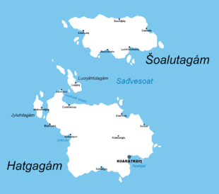
 Map of the archipelago | |
| Etymology | iŋiq 'puffin' + agáin 'archipelago' |
| Geography | |
| Location | The Sea of Alpa |
| Total islands | 24 |
| Major islands | 2 |
| Highest elevation | 715 m (2,346 ft) |
| Highest point | Aŋašilip |
| Country | |
| Capital city | Koarátkeiŋ |
| Largest settlement | Koarátkeiŋ (pop. 17,018) |
| Demographics | |
| Population | 35,103 (as of 2015) |
| Ethnic groups | Yokultans, Durykians |
| Additional information | |
| Time zone |
|
Iŋiqagáin archipelago (Niryokulta: Iŋiqagáin [ˈɪŋɪqaˌkæ:jn]) is an archipelago located in southeastern Akamyokulta. It consists of two major islands, Hatgagám and Šoalutagám separated by a sea (or a channel, precisely) called Sađvesoat, and other 22 smaller islands, often uninhabited. The archipelago also makes up the Hatgalaš municipality.