Difference between revisions of "Lake Heshov"
Jump to navigation
Jump to search
m |
Yrieixgroulx (talk | contribs) |
||
| Line 1: | Line 1: | ||
{{Infobox body of water | {{Infobox body of water | ||
| name = Lake Heshov | | name = Lake Heshov | ||
| native_name = {{cs|AGZ| | | native_name = {{cs|AGZ|kesh heshav}} | ||
| native_name_lang = Algaz | | native_name_lang = Algaz | ||
| other_name = | | other_name = | ||
Latest revision as of 01:32, 28 January 2022
| Lake Heshov kesh heshav | |
|---|---|
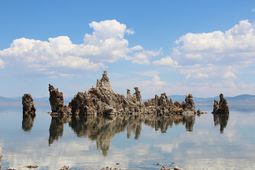
 Tufa formations near the lake's northern shore | |
| Location | |
| Type | Endorheic |
| Primary inflows | seasonal streams |
| Primary outflows | evaporation |
| Catchment area | 180,559.47 km2 (69,714.40 sq mi) |
| Surface area | 1,332.16 km2 (514.35 sq mi) |
| Max. depth | 34 m (112 ft) |
| Water volume | 6.2 km3 (5,000,000 acre⋅ft) |
| Salinity | 68 g/L |
| Shore length1 | 195.73 km (121.62 mi) |
| 1 Shore length is not a well-defined measure. | |
Lake Heshov (Algaz: Kesh Heshav) is a large, extremely saline lake located in the Algazi Union. Known for its salt-encrusted tufa rock formations, the lake is an important tourist destination, particularly for Algazi visitors. Lake Heshov has historically had a great deal of religious significance for the Algazi; salt from the lake is valued for its apotropaic properties, though collection is highly limited due to the lake's protected status.
| This article about a geographical location is a stub. You can help CWS Planet by expanding it. |