Archive:Lvó River
Revision as of 00:02, 29 May 2020 by Ava (talk | contribs) (Ava moved page Lvó River to Category:Lvó River)
 | This article or section is out of date. A country/countries relevant to this article have been removed from Sahar and have been retconned. Not everything here may still be considered canonical. This page was last edited by Ava (talk | contribs) 3 years ago. (Update) |
| Lvó River | |
|---|---|
 | |
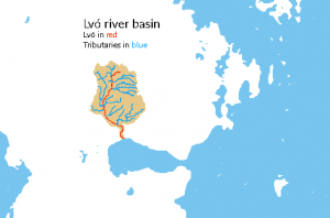
 Hydrographic map of the Lvó basin, with red marking the Lvó, and blue marking tributaries. | |
| Native name | Lepo (Fáknir) |
| Other name(s) | Lebo (Finnic) Lvó (Saavdis) Zevu (Ellsic) |
| Etymology | Unknown, possibly pre-Fals |
| Basin | |
| River mouth | Lvóthel, Fáknirland, Fals Empire |
| Countries | |
| Cities | Pogašček, Porodórex, Lvóvluul, Egsan, Oynifánis, Darmat |
| Population | ~10,022,000 |
| Physiognomy | |
| Length | 1,315.29 kilometres (817.28 mi) |
| Discharge |
|
The Lvó River (Fáknir: En Pols Ke Lepo (IPA: /ɛn pʰoɫs̪ kʰɛ ɫɛpʰo/); Finnic: En Boles Ke Lebo (IPA: /ɛn bolʷɛs kɛ lʷɛboˀ/); Saavdis: Vla Lvó (IPA: /vlɑ ɮvoː/); Ellsic: An-Tór Wók-Zevu (IPA: /ɒntoːr ɸoːgzævɯ/)) is a large river in southern Central Boroso.