Difference between revisions of "Mažatarisav"
| Line 117: | Line 117: | ||
}} | }} | ||
'''Mažatarisav'''({{small|[[Siyan]]:}} [Maʒatarɪsɐv]), also known as Mažav as local slang in the modern age, is a metropolitan city in the northern island of the province of Ževuzah. The city has a population of 1.122 million in its urban center, making it [[Lenezan]]'s fifth-largest city after [[Afąván]], [[Doremarah]], [[Ihana]], and [[ | '''Mažatarisav'''({{small|[[Siyan]]:}} [Maʒatarɪsɐv]), also known as Mažav as local slang in the modern age, is a metropolitan city in the northern island of the province of Ževuzah. The city has a population of 1.122 million in its urban center, making it [[Lenezan]]'s fifth-largest city after [[Afąván]], [[Doremarah]], [[Ihana]], and [[Asolaňepa]]. | ||
Mažatarisav has more than 2,500 years of recorded urban history, and up to 5,500 years of history as a human settlement since the Neolithic period. Their interactions have first been recorded around 105 CE, by Letsatian traders who've begun a material exchange with the islanders. A small Letsatian outpost would be there to cement authority for a short time before soldiers were retrieved prior to collapse, hence the reasoning behind it's previous name: Bẽnastúϑita (East Order). Iovism would be introduced to the Ževuzah islands, allowing the religions to thrive there for centuries until anti-foreigner sentiments from the Yeshub caused the expulsion/conversion of hundreds of thousands in the early 1400s. The island would be incorporated soon after into the Kingdom of Lenezan in 1405, and renamed to Mažatarisav (Tower On The Island) as a part of Siyanizing the region. However the name Bẽnastúϑita would be in use throughout many Ekuosian maps, namely Terminian, until the mid-1600s. Lying on an advantageous location at the center of the Gulf of Sharkunen, it is used as a mercantile city and waypoint for much of it's history. It was between the Vos port city of Tameyvah and the Lugid capital city of Nataliya. | Mažatarisav has more than 2,500 years of recorded urban history, and up to 5,500 years of history as a human settlement since the Neolithic period. Their interactions have first been recorded around 105 CE, by Letsatian traders who've begun a material exchange with the islanders. A small Letsatian outpost would be there to cement authority for a short time before soldiers were retrieved prior to collapse, hence the reasoning behind it's previous name: Bẽnastúϑita (East Order). Iovism would be introduced to the Ževuzah islands, allowing the religions to thrive there for centuries until anti-foreigner sentiments from the Yeshub caused the expulsion/conversion of hundreds of thousands in the early 1400s. The island would be incorporated soon after into the Kingdom of Lenezan in 1405, and renamed to Mažatarisav (Tower On The Island) as a part of Siyanizing the region. However the name Bẽnastúϑita would be in use throughout many Ekuosian maps, namely Terminian, until the mid-1600s. Lying on an advantageous location at the center of the Gulf of Sharkunen, it is used as a mercantile city and waypoint for much of it's history. It was between the Vos port city of Tameyvah and the Lugid capital city of Nataliya. | ||
Revision as of 04:26, 15 May 2023
Mažatarisav | |
|---|---|
Metropolis | |
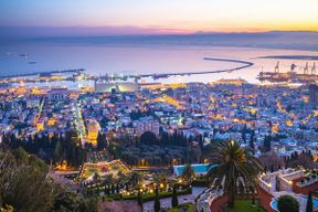
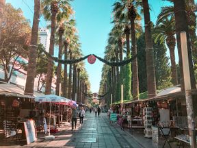
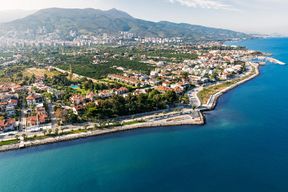
Top to Bottom, Left to Right: View of Uptown Mažatarisav at night, Zebave Botanical Shrines , Vukahętah Street in Ňepozan, Bíkava Palm Farmer's Market, View of Mažatarisav Marine District, Mažatarisav Square Clock Tower in Downtown Mažatarisav, Aerial View of Central Mažatarisav | |
| Etymology: Tower on the Island | |
| Nickname(s): The Elder Twin | |
| Country | Lenezan |
| Region | Islands |
| Area | |
| • Metro | 1,004 km2 (388 sq mi) |
| Population (2019) | |
| • Metropolis | 1,122,450 |
| • Density | 1,541/km2 (3,990/sq mi) |
| Demonym(s) | Mažatarisavi |
| Time zone | Sahar Coordinated Time (SCT+2) |
Mažatarisav(Siyan: [Maʒatarɪsɐv]), also known as Mažav as local slang in the modern age, is a metropolitan city in the northern island of the province of Ževuzah. The city has a population of 1.122 million in its urban center, making it Lenezan's fifth-largest city after Afąván, Doremarah, Ihana, and Asolaňepa.
Mažatarisav has more than 2,500 years of recorded urban history, and up to 5,500 years of history as a human settlement since the Neolithic period. Their interactions have first been recorded around 105 CE, by Letsatian traders who've begun a material exchange with the islanders. A small Letsatian outpost would be there to cement authority for a short time before soldiers were retrieved prior to collapse, hence the reasoning behind it's previous name: Bẽnastúϑita (East Order). Iovism would be introduced to the Ževuzah islands, allowing the religions to thrive there for centuries until anti-foreigner sentiments from the Yeshub caused the expulsion/conversion of hundreds of thousands in the early 1400s. The island would be incorporated soon after into the Kingdom of Lenezan in 1405, and renamed to Mažatarisav (Tower On The Island) as a part of Siyanizing the region. However the name Bẽnastúϑita would be in use throughout many Ekuosian maps, namely Terminian, until the mid-1600s. Lying on an advantageous location at the center of the Gulf of Sharkunen, it is used as a mercantile city and waypoint for much of it's history. It was between the Vos port city of Tameyvah and the Lugid capital city of Nataliya.
As of 2016, it shares a major seaport for Lenezan with it's sister island to the south, Doremarah. It also shares the respected academic institution of the Siyan University of Doremarah and Mažatarisav, which remains a top-ranked university in mathematics, literature, and lingustics within Lenezan and Vaniua. The city still plays an important role to the Lenezi economy, due to it being a center of shipbuilding and commerce. It also hosts the Âr Kvisåne games, and draws in nearly a billion dollars from gambling/tourism. It holds an infamous title in the region, as it is one of the only places in Vaniua where it is legal to gamble and/or run a casino due to a legislative loophole. As a result, it's also a favorite spot to host the Loleno Yunuḍe â zur Âr Kvisåno's (International Federation for the Golden Races) biennial horseracing tournaments.
Etymology
Despite being renamed in 1405, the origins for the name of Mažatarisav would extend further back to ancient times as Letsatians colloquially named it as Bẽnastúϑita because it was a place of order in the east, that helped support its campaigns on the Lenezi city states and Vos coast. The island was dotted with numerous watchtowers that have since decayed from the days of the Letsatian island outpost. Drawing inspiration from this, the Lenezi general placed in charge of the island named it Mažatarisav that literally meant "Tower on the Island".
History
Geography
Mažatarisav is located on the North Ževuzah island, south of the Lenezi mainland, near the city of Doremarah in South Ževuzah. The city is surrounded by flat terrain, with a few hills dotted around the island.
Climate
Mažatarisav experiences a hot-summer Mediterranean climate (Köppen climate classification: Csa), as the rainiest seasons are autumn and spring, with this strongly affected by being located on an island. It is one of the warmest Mediterranean climates for its latitude. Summers are warm to hot, dry, and sunny. During this season, rainfall is infrequent with only one or two measurable days in a typical July. The temperature generally stays above 26°C (79°F), but rarely exceeds 32°C (90°F). Climate data is recorded at the airport, located near the sea, which often results in higher summer temperatures in the city. In July and August, the average maximum temperature reaches about 27°C (81°F), with the highest recorded temperature being 37.7°C (99.9°F) on August 1, 2006. Autumn usually starts with sunny September days that gradually become more cloudy and rainy towards October. Temperatures typically remain above 20°C (68°F) until November, when days start cooling down to around 17°C (63°F).
Winters are mild during the day, ranging from 11 to 17°C (52 to 63°F), and cool at night, from 4 to 9°C (39 to 48°F), with variable weather. Days can either be sunny and dry or damp and rainy, with frost being rare and snowfall even more uncommon. The most recent snowfall in Mažatarisav occurred on February 26, 2018, with dustings also occurring in 2005, 2009, and 2010. Spring starts cool and rainy in late March, but Mažatarisav gradually becomes warmer and sunnier around June.
| Climate data for Mažatarisav (Dove Havišir Airport) (1981–2020 for normals, 1956-present) | |||||||||||||
|---|---|---|---|---|---|---|---|---|---|---|---|---|---|
| Month | Jan | Feb | Mar | Apr | May | Jun | Jul | Aug | Sep | Oct | Nov | Dec | Year |
| Record high °C (°F) | 22.5 (72.5) |
25.8 (78.4) |
26.1 (79) |
26.1 (79) |
31.4 (88.5) |
36.8 (98.2) |
37.0 (98.6) |
33.9 (93) |
33.7 (92.7) |
29.9 (85.8) |
25.4 (77.7) |
22.0 (71.6) |
37.7 (99.9) |
| Average high °C (°F) | 13.3 (55.9) |
13.5 (56.3) |
15.4 (59.7) |
17.4 (63.3) |
21.0 (69.8) |
24.7 (76.5) |
27.5 (81.5) |
27.9 (82.2) |
24.8 (76.6) |
21.0 (69.8) |
17.0 (62.6) |
14.1 (57.4) |
19.8 (67.6) |
| Daily mean °C (°F) | 9.5 (49.1) |
9.8 (49.6) |
11.8 (53.2) |
14.1 (57.4) |
17.7 (63.9) |
21.4 (70.5) |
24.1 (75.4) |
24.5 (76.1) |
21.2 (70.2) |
17.5 (63.5) |
13.3 (55.9) |
10.3 (50.5) |
16.3 (61.3) |
| Average low °C (°F) | 5.8 (42.4) |
6.1 (43) |
8.3 (46.9) |
10.8 (51.4) |
14.5 (58.1) |
18.1 (64.6) |
20.8 (69.4) |
21.1 (70) |
17.7 (63.9) |
14.0 (57.2) |
9.7 (49.5) |
6.6 (43.9) |
12.8 (55) |
| Record low °C (°F) | −7.2 (19) |
−5.8 (21.6) |
−5 (23) |
2.9 (37.2) |
3.7 (38.7) |
8.1 (46.6) |
11.7 (53.1) |
11.4 (52.5) |
7.6 (45.7) |
4.2 (39.6) |
0.1 (32.2) |
−2.7 (27.1) |
−7.2 (19) |
| Average rainfall mm (inches) | 73.5 (2.894) |
53.6 (2.11) |
51.0 (2.008) |
68.8 (2.709) |
40.3 (1.587) |
35.7 (1.406) |
13.6 (0.535) |
17.2 (0.677) |
81.0 (3.189) |
127.9 (5.035) |
138.4 (5.449) |
90.3 (3.555) |
791.3 (31.154) |
| Average rainy days (≥ 1.0 mm) | 5.8 | 5.1 | 4.9 | 6.4 | 5.1 | 3.8 | 1.8 | 2.3 | 4.9 | 7.5 | 8.5 | 6.0 | 62.1 |
| Source: Lenezi Meteorological Agency | |||||||||||||


