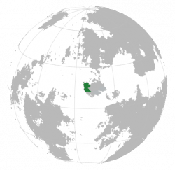
Difference between revisions of "Magali"
Jump to navigation
Jump to search
m |
|||
| Line 104: | Line 104: | ||
|cctld = <!--Internet country code top-level domain identifier (e.g. [[.br]], [[.de]], etc) | |cctld = <!--Internet country code top-level domain identifier (e.g. [[.br]], [[.de]], etc) | ||
|iso3166code = <!--Use to override default from common_name parameter above; omit using "omit".--> | |iso3166code = <!--Use to override default from common_name parameter above; omit using "omit".--> | ||
|calling_code = [[+ | |calling_code = [[+21]] | ||
|image_map3 = <!--Optional third map position, e.g. for use with reference to footnotes below it--> | |image_map3 = <!--Optional third map position, e.g. for use with reference to footnotes below it--> | ||
|alt_map3 = <!--alt text for third map position--> | |alt_map3 = <!--alt text for third map position--> | ||
Revision as of 20:38, 29 April 2017
| Republic of Kwagali Kwâkarí, Kåkådli |
||||
|---|---|---|---|---|
|
||||
| Capital and | Magali | |||
| Regional languages | Teixo, Yavodna, Caniri Jargon | |||
| Demonym | Magalese | |||
| Government | ||||
| - | Leader | |||
| Area | ||||
| - | 367,472 km2 141,882 sq mi |
|||
| Population | ||||
| - | estimate | 51,115,000 | ||
| - | Density | 139/km2 360/sq mi |
||
| Gini | 29 low |
|||
| HDI | 0.808 very high |
|||
| Time zone | SCT -1 | |||
| - | Summer (DST) | not observed (SCT) | ||
| Drives on the | right | |||
| Calling code | +21 | |||
Magali
Etymology
Magali
History
Geography
Geology
Climate
Biodiversity
Politics
Government
Administrative divisions
Foreign relations
Military
Economy
Transport
Energy
Science and technology
Tourism
Demographics
Ethnic groups
Urbanisation
Language
Education
Healthcare
Religion
Culture
Heritage
Architecture
Literature
Art
Music
Theatre
Film
Cuisine
Sport
Symbols
See also
[[Category:Magali]

