Maydveki
Jump to navigation
Jump to search
| Máydveki | |
|---|---|
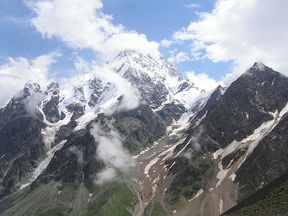
 Máydveki's eastern face as seen from Oyazan at noon in the summertime. | |
| Highest point | |
| Elevation | 4,881 m (16,014 ft) |
| Prominence | 2,002 m (6,568 ft) |
| Listing | Four-thousander Oyazan highest point |
| Geography | |
| Location | Sirbia Autonomous Republic, Oyazan Istlurlobe |
| Parent range | Rolovian mountain range |
Maydveki (Sirbían: Máydveki [ˈmaj.tfe.kʰi]) is Oyazan's highest mountain. It is located in the Rolovian mountain range, and its peak is 4,861 metres (15,948 ft) above sea level. The international border between Istlurlobe and Oyazan runs across its summit.