Difference between revisions of "Mount Ehesengum"
Litrobotix (talk | contribs) (Fixed) |
Litrobotix (talk | contribs) (edited) |
||
| Line 60: | Line 60: | ||
==Geography and climate== | ==Geography and climate== | ||
Standing {{convert|5681|m|ft}} high, Mount Ehesengum is a distinctive feature of the geography of Atameng. The mountain is located in the Ame'angta Mountains. As a National Park, the Mount Ehesengum area is under direct control of the state government of [[Kiuhuni Province]] | Standing {{convert|5681|m|ft}} high, Mount Ehesengum is a distinctive feature of the geography of Atameng. The mountain is located in the Ame'angta Mountains. As a National Park, the Mount Ehesengum area is under direct control of the state government of [[Kiuhuni Province]]. | ||
Climate of Mount | Climate of the Mount Ehesengum region is dominated by a humid subtropical climate. Due to the humid temperature of the area and despite the high altitude, the temperatures near the summit only average around {{convert|-2|C|F}}. The Mount Ehesengun area mostly falls above the [[Wikipedia:Tree line|tree line]] which lies around altitudes between {{convert|2300|m|ft|abbr=on}} and {{convert|2800|m|ft|abbr=on}}. At these areas, grass and rocks dominate the landscape, and vegetation is otherwise scarce. | ||
{{Weather box|location = {{convert|4900|m|ft|abbr=on}} | {{Weather box|location = {{convert|4900|m|ft|abbr=on}} | ||
Revision as of 22:54, 9 November 2018
| Mount Ehesengum | |
|---|---|
| Hohowoa | |
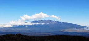
 Mount Ehesengum, as seen from the Okama Hills | |
| Highest point | |
| Elevation | 5,681 m (18,638 ft) |
| Prominence | 5,681 m (18,638 ft) |
| Parent peak | None |
| Listing | Highest peak in Atameng Ultra-prominent peaks |
| Coordinates | 31°33'23"N, 0°27'02"E |
| Naming | |
| Native name | Hohoakapi |
| Translation | "Divine construction" (Amakane) |
| Geography | |
| Location | Kiuhuni Province, Atameng |
| Parent range | Ame'angta Mountains |
| Geology | |
| Mountain type | Shield volcano (dormant) |
| Last eruption | 689 CE |
| Climbing | |
| First ascent | 1812 |
| Normal route | Uieka route |
Mount Ehesengum (Amakane: Hohoakapi [hohoakapi]) is a dormant shield volcano located in the Ame'angta Mountains in Atameng. At 5,681 metres (18,638 ft) above sea level, the mountain is both the tallest in Atameng and in the Ame'angta Mountains, as well as the highest point in Atsiq.
In order conserve and protect the forests and fauna around the mountain, Mount Ehesengum National Park, comprising Mount Ehesengum and surrounding areas, was established in 1963, and has become a popular tourist site.
Etymology
Ehesengum derives from the Amakane words meaning "divine" and "brick" widely interpreted as meaning "divine construction." Another possible etymology is that "Ehesengum" derives from Eheseng, the legendary explorer who first discovered Kaina Lake, a small lake located at the foot of the mountain.
Geography and climate
Standing 5,681 metres (18,638 ft) high, Mount Ehesengum is a distinctive feature of the geography of Atameng. The mountain is located in the Ame'angta Mountains. As a National Park, the Mount Ehesengum area is under direct control of the state government of Kiuhuni Province.
Climate of the Mount Ehesengum region is dominated by a humid subtropical climate. Due to the humid temperature of the area and despite the high altitude, the temperatures near the summit only average around −2 °C (28 °F). The Mount Ehesengun area mostly falls above the tree line which lies around altitudes between 2,300 m (7,500 ft) and 2,800 m (9,200 ft). At these areas, grass and rocks dominate the landscape, and vegetation is otherwise scarce.
| Climate data for 4,900 m (16,100 ft) | |||||||||||||
|---|---|---|---|---|---|---|---|---|---|---|---|---|---|
| Month | Jan | Feb | Mar | Apr | May | Jun | Jul | Aug | Sep | Oct | Nov | Dec | Year |
| Record high °C (°F) | 12 (54) |
12 (54) |
11 (52) |
12 (54) |
16 (61) |
14 (57) |
23 (73) |
13 (55) |
15 (59) |
14 (57) |
11 (52) |
12 (54) |
23 (73) |
| Average high °C (°F) | 4.6 (40.3) |
4.8 (40.6) |
3.7 (38.7) |
4 (39) |
7.4 (45.3) |
8.9 (48) |
9.6 (49.3) |
8 (46) |
9.2 (48.6) |
5.4 (41.7) |
6.7 (44.1) |
4.1 (39.4) |
6.6 (43.9) |
| Average low °C (°F) | −4.8 (23.4) |
−4.3 (24.3) |
−4.6 (23.7) |
−4.5 (23.9) |
−2.2 (28) |
−2.1 (28.2) |
−1.5 (29.3) |
−1.6 (29.1) |
−1.2 (29.8) |
−2.2 (28) |
−3.8 (25.2) |
−3.2 (26.2) |
−2 (28) |
| Record low °C (°F) | −8 (18) |
−12 (10) |
−9 (16) |
−9 (16) |
−12 (10) |
−6 (21) |
−7 (19) |
−9 (16) |
−6 (21) |
−8 (18) |
−8 (18) |
−9 (16) |
−12 (10) |
| Source: Atamengian Climate Survey, as of 2010 | |||||||||||||