Difference between revisions of "Archive:Mujansa"
m |
m |
||
| Line 4: | Line 4: | ||
''Tanthemsa Mucansasā'' (Anchashi) <!--Country's name (usually full name) in its native language, hence in italics (double quotemarks)--> | ''Tanthemsa Mucansasā'' (Anchashi) <!--Country's name (usually full name) in its native language, hence in italics (double quotemarks)--> | ||
|common_name =Mujansa <!--Common name in English (used for wikilinks and to produce a default iso3166 code)--> | |common_name =Mujansa <!--Common name in English (used for wikilinks and to produce a default iso3166 code)--> | ||
|image_flag = | |image_flag = MujansanFlag.png <!--e.g. Flag of country.svg--> | ||
|alt_flag = <!--alt text for flag (text shown when pointer hovers over flag)--> | |alt_flag = <!--alt text for flag (text shown when pointer hovers over flag)--> | ||
|image_flag2 = <!--e.g. Second-flag of country.svg--> | |image_flag2 = <!--e.g. Second-flag of country.svg--> | ||
Revision as of 19:48, 24 January 2022
| Union of Mujansa Dintēm Mu Ṛan (Jaiso) Tanthemsa Mucansasā (Anchashi) |
||||
|---|---|---|---|---|
|
||||
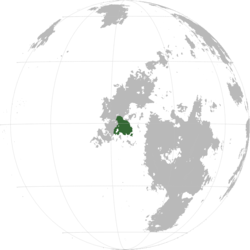
Mujansa in Nagu
|
||||
| Capital and | Kỹháṛi | |||
| Official languages | Jaiso Anchashi |
|||
| Recognised regional languages | Yurija-Yakuna languages Mlangic languages |
|||
| Demonym | Mujansan | |||
| Government | Directorial Republic | |||
| Establishment | ||||
| - | Conquest by the Cananganamese Empire | 9 BCE | ||
| Area | ||||
| - | 611,855.72 km2 236,238.8142085 sq mi |
|||
| Population | ||||
| - | estimate | 51.395.880 | ||
| - | census | 50.170.00 | ||
| - | Density | 84/km2 217.6/sq mi |
||
Mujansa (Jaitho: Dintēm Mu Ṛan din˧tʰem˥ mu˧ ɻan˧), officially the Republic of Mujansa, is a country located in Nagu, bordered by Cananganam and Ukutunajas in the west.
Etymology
The name "Mujansa" comes from proto-Gyai *mu˩˧ du˩ jan˩ sa˩˧, with the meaning “Land of the many islands”, loaned into Canana as Mūduyansa, later reloaded into Jaitho as Mu Ran
History
Pre-Canamic era
Proto-Gyai speakers migrated into the area around the 1st century CE. By X, there was a large amount of land ruled by local lords who swore allegiance to the emperor back in Rem Kam Bam. The rivers X and X were vital, as they were the main way of carrying goods, people and soldiers around the domains.
Canamic conquest
In year X, the Canamic empire launched a campaign headed by general Nagaajeekhaa Saẓeeṭṣee in response to increased raids and attacks by the native Dagyelics. He defeated emperor Jỹ Lú at the battle of Ṭin, then proceeded to travel around the empire, forcing nobles to capitulate.
Geography
Geology
Climate
Biodiversity
Politics
Government
Mujansa is a directorial republic where the role of head of government is filled by the 35-seated Council of Yazas. It is presided by a byaźā, the head of state elected by the council itself. A yaza (Anchashi yāzā /ˈja.za/) refers to an elected province governor, which also serves as it's representative on the national level. Each yaza is the head of the government of their respective yazate (province), which have a high level of autonomy due to the country's decentralised nature.
Administrative divisions
Mujansa is divided into 35 yazates.


