Difference between revisions of "Archive:Otofu"
| Line 1: | Line 1: | ||
{{Infobox settlement | {{Infobox settlement | ||
| name = Otofu City | | name = Otofu City | ||
| native_name = Otofu | | native_name = Otofu Farhofon | ||
| native_name_lang = EKM | | native_name_lang = EKM | ||
| settlement_type = <!-- Leave this line blank! It will give you loose </th></tr> tags at the top of the page --> | | settlement_type = <!-- Leave this line blank! It will give you loose </th></tr> tags at the top of the page --> | ||
| Line 110: | Line 110: | ||
===Administrative Divisions=== | ===Administrative Divisions=== | ||
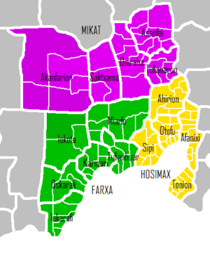
The quint of [[ | The quint of [[Otoihofa-io-Hosimax|Hosimax]], which houses the federal capital is located at the mouth of the Otoihofa River, which flows into the [[Bay of Simaxifo]]. With 236,000 kavrinh living in its five towns, over two-fifths of the population of Otofu live in this quint. The towns of [[Otofu Municipality|Otofu]] and [[Afanixi]], the two most populous settlements in Yakormonyo, along with the port town of [[Tonion]] are found here. | ||
North of Hosimax is [[ | North of Hosimax is [[Otoihofa-io-Farxa|Farxa]], which surrounds the [[Bay of Simaxifo]]. Farxa is much bigger and a thriving rural population lives in its eastern extremes, fed by the [[Karinari River]]. The largest settlements here are [[Karinari]] and [[Tufianhuar]], which along with four more towns give a total population of 196,000. | ||
Upstream from the mouth of the Otoihofa leads to the quint of [[Otoihofa-io-Mikat|Mikat]]. It has a combined population of 134,000 in its five towns, the largest being [[Asanfoi]]. In the northeast the town of [[Akanfarion]] is home to large swathes of common land. | Upstream from the mouth of the Otoihofa leads to the quint of [[Otoihofa-io-Mikat|Mikat]]. It has a combined population of 134,000 in its five towns, the largest being [[Asanfoi]]. In the northeast the town of [[Akanfarion]] is home to large swathes of common land. | ||
| Line 118: | Line 118: | ||
[[File:Otofu labeled.png|thumbnail||Map of Otofu City. Towns in Hosimax are coloured yellow, those in Farxa green, and those in Mikat purple.]] | [[File:Otofu labeled.png|thumbnail||Map of Otofu City. Towns in Hosimax are coloured yellow, those in Farxa green, and those in Mikat purple.]] | ||
===Climate=== | |||
==Cityscape== | |||
<!-- If it is for a city, you can include here various categories such as "Prominent buildings", "Parks", "Streets and squares", "Bridges", etc. --> | |||
==Culture== | |||
<!--Include sections like "Museums", "Festivals", "Sports", etc.--> | |||
==Economy== | |||
==Government== | |||
==Demographics== | |||
{| class="wikitable sortable" | {| class="wikitable sortable" | ||
|- | |- | ||
| Line 155: | Line 168: | ||
|} | |} | ||
==International relations== | ==International relations== | ||
Revision as of 14:10, 21 September 2020
Otofu City
Otofu Farhofon | |
|---|---|
| Nickname(s): The Heart of the South Kav | |
| Motto(s): Si'kata Far i Xosapi axi Amanofu! Our Heart and Wings are Strong! | |
| Country | Yakormonyo |
| Province | Asaka |
| Prefecture | Otoihofa |
| Quint (Otoihofa-io-Hosimax) | 1991 |
| Founded by | Unknown |
| Population (2020) | |
| • Total | 566,000 |
| Demonym(s) | Otokio |
| Time zone | -2:30 |
Otofu City (Monyo: Otofu Farhofon /ʌtʌse saɾxʌsʌn/) is an informal subdivision of Otoihofa Prefecture consisting of the quints of Hosimax, Farxa and Mikat. Hosimax in particular is the most populated quint of Yakormonyo and has served as the capital of the nation since its independence from Yahara in the 16th century, however modern-day usage of the term "Otofu City" has included the contiguous Farxa and Mikat quints.
Etymology
The name 'Otofu' came from the Old Monyo word ottöffu (wet), referring to its location in the mouth of the Otoihofa River.
History
16th Century (WIP)
Before 1515, Öto Upu (what it was called then) was one of the northernmost towns in the Yaharan Empire, in the Duchy of Ësnvøërvërg. When the Empire broke up, Öto Upu and its surrounding towns of Repöča (Repoşota), Sämežxemí (Samejkhemy), Ítona (Ytona) and Vommä (Voma) declared their independence as the Duchy of Ësnvøërvërg, eventually followed by other towns in the Toşe region. Eventually Ësnvøërvërg was renamed to the Duchy of Otofu. It became the capital of Otofu until the nation united with the neighboring Duchy of Peccy (Pekha), wherein the capital was moved to Ony. On 1565, by order of Duke Otohua Samejkhemy, Oto Upu (renamed to Otofu) became the capital of the United Duchies of Peccy-Otofu.
Geography
Administrative Divisions
The quint of Hosimax, which houses the federal capital is located at the mouth of the Otoihofa River, which flows into the Bay of Simaxifo. With 236,000 kavrinh living in its five towns, over two-fifths of the population of Otofu live in this quint. The towns of Otofu and Afanixi, the two most populous settlements in Yakormonyo, along with the port town of Tonion are found here.
North of Hosimax is Farxa, which surrounds the Bay of Simaxifo. Farxa is much bigger and a thriving rural population lives in its eastern extremes, fed by the Karinari River. The largest settlements here are Karinari and Tufianhuar, which along with four more towns give a total population of 196,000.
Upstream from the mouth of the Otoihofa leads to the quint of Mikat. It has a combined population of 134,000 in its five towns, the largest being Asanfoi. In the northeast the town of Akanfarion is home to large swathes of common land.
Climate
Cityscape
Culture
Economy
Government
Demographics
| Name | Population (2020) | Quint | Founded |
|---|---|---|---|
| Otofu | 56,000 (9.9%) | Hosimax | |
| Afanixi | 51,000 (9.0%) | Hosimax | |
| Tonion | 48,000 (8.5%) | Hosimax | |
| Ahirion | 44,000 (7.8%) | Hosimax | |
| Tufianhuar | 43,000 (7.6%) | Farxa | |
| Karinari | 40,000 (7.1%) | Farxa | |
| Sipi | 37,000 (6.5%) | Hosimax | |
| Iokarafi | 36,000 (6.4%) | Farxa | |
| Asanfoi | 33,000 (5.8%) | Mikat | |
| Tufianarun | 29,000 (5.1%) | Mikat | |
| Oskarak | 28,000 (4.9%) | Farxa | |
| Oniraha | 27,000 (4.8%) | Mikat | |
| Miarfo | 26,000 (4.6%) | Farxa | |
| Saktxama | 24,000 (4.2%) | Mikat | |
| Iokota | 23,000 (4.1%) | Farxa | |
| Akanfarion | 21,000 (3.7%) | Mikat |

