Difference between revisions of "Saru Sea"
m (Added Cúfti to list of cities) |
|||
| Line 51: | Line 51: | ||
| trenches = | | trenches = | ||
| benches = | | benches = | ||
| cities = Capital cities on the Saru include:<br>[[Deugyeu]], [[Grø Mithabej]], [[Jute City]], [[Moraun]], [[Pyösonon]], [[Riges]], [[Yisma]] | | cities = Capital cities on the Saru include:<br>[[Deugyeu]], [[Grø Mithabej]], [[Jute City]], [[Moraun]], [[Pyösonon]], [[Riges]], [[Yisma]], [[Cúfti]] | ||
| pushpin_map = <!-- the name of a location map as per Template:Location map. Requires coordinates in latd= and longd= format --> | | pushpin_map = <!-- the name of a location map as per Template:Location map. Requires coordinates in latd= and longd= format --> | ||
| pushpin_label_position = <!-- left, right, top or bottom --> | | pushpin_label_position = <!-- left, right, top or bottom --> | ||
Revision as of 14:36, 16 October 2021
| Saru Sea | |
|---|---|
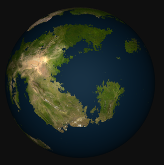
 The Saru Sea on a satellite map | |
| Type | Sea or Ocean |
| Settlements | Capital cities on the Saru include: Deugyeu, Grø Mithabej, Jute City, Moraun, Pyösonon, Riges, Yisma, Cúfti |
The Saru Sea, also simply called the Saru, is one of Sahar's many seas which may be considered part of the Asura Ocean, although it is better-defined than many of the other open bodies of water on Sahar. It is delimited by island of NAME in Osteria in the south, and the western coast of Baredina to the west and north. Part of its eastern bounds is marked by the east coast of Ystel, but the north-east boundaries are not clear. Typically they are drawn to include Jute or to use it as the border. Sometimes the Sañu Strait and waters east of Jute are included, which then allows the north of Ystel and the south of Lahan to be considered borders of the Saru.
The Saru is often subdivided into northern and southern halves due to the strong difference in the climates of the regions surrounding it.