Difference between revisions of "Tarkhan Mountains"
Jump to navigation
Jump to search
m |
|||
| (3 intermediate revisions by the same user not shown) | |||
| Line 37: | Line 37: | ||
</gallery> | </gallery> | ||
[[Category:Mountains]] | |||
[[Category: | [[Category:Tarkhan Mountains]] | ||
[[Category: | [[Category:Geography of Miraria]] | ||
[[Category: | |||
[[Category:Golden Plateau]] | [[Category:Golden Plateau]] | ||
[[Category:Ecoregions of Miraria]] | [[Category:Ecoregions of Miraria]] | ||
[[Category:Komania]] | |||
[[Category:Balakia]] | |||
[[Category:Vaniua]] | [[Category:Vaniua]] | ||
Revision as of 19:30, 23 January 2021
| Tarkhan | |
|---|---|
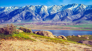
 Qazmezaram, highest point in the Tarkhan Mountains | |
| Highest point | |
| Peak | Qazmezaram |
| Elevation | 4,889 m (16,040 ft) |
| Dimensions | |
| Length | 2,463.9 km (1,531.0 mi) |
| Width | 1,281.3 km (796.2 mi) |
| Geography | |
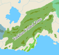
 Part of the Greater Vaniuan fold and thrust belt, with the Tarkhan Mountains in dark green
| |
| Location | Komania, Balakia, Kaatkukia, Zinsha-Vogia, Ohania and Gushlia or Eastern Vaniua |
| Geology | |
| Age of rock | Carboniferous |
| Mountain type | Fold and thrust belt |

