Difference between revisions of "Translira"
Jump to navigation
Jump to search
| Line 62: | Line 62: | ||
|area = <!--Major area size (in [[Template:convert]] either km2 or sqmi first)--> | |area = <!--Major area size (in [[Template:convert]] either km2 or sqmi first)--> | ||
|area_km2 = 3 884 771 <!--Major area size (in square km)--> | |area_km2 = 3 884 771 <!--Major area size (in square km)--> | ||
|area_sq_mi = | |area_sq_mi = 1 499 918 <!--Major area size (in square mi)--> | ||
|area_footnote = <!--Optional footnote for area--> | |area_footnote = <!--Optional footnote for area--> | ||
|percent_water = | |percent_water = | ||
Revision as of 05:08, 13 March 2017
| Translira Tŕânclira |
||||
|---|---|---|---|---|
|
||||
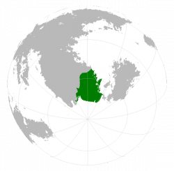
Translira as viewed from the bottom of a globe.
|
||||
| Capital | Grên Pniþagès | |||
| Largest | Gyäkûþic | |||
| Official languages | Atruozan | |||
| Minority language | Sjuutsay | |||
| Demonym | Transliran | |||
| Area | ||||
| - | 3 884 771 km2 (2) 1 499 918 sq mi |
|||
| Population | ||||
| - | 2016 census | 6 142 539 | ||
| - | Density | 1.58/km2 4.1/sq mi |
||
| Calling code | +69 | |||
Translira (IPA: /tran.ˈslir.ə/, Native language: Tŕânclira, IPA: /t̪ʀɑ̃.ʃli.ˈra/) is a country located on the southern tip of South Baredina that borders Sjuu to its north. Slightly more than half the country lies south of the Antarctic Circle, and all but a small portion of it to the north is either ice cap, tundra or subarctic taiga. It borders the Chistonawe Sea to its south, and the southern reaches of the Saru sea (that lie between South Baredina and Ystel) to its east.

