Difference between revisions of "Translira"
| Line 191: | Line 191: | ||
==See also== | ==See also== | ||
[[Category:Translira]][[Category:Countries]][[Category:Baredina]][[Category:South Baredina]][[Category:Atruozia]][[Category:Country stubs]] | |||
Revision as of 01:04, 6 April 2019
| Directorial Republic of Translira Tŕãclirä |
||||
|---|---|---|---|---|
|
||||
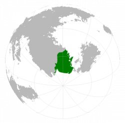
Translira as viewed from the bottom of a globe.
|
||||
| Capital | Grø̃ Pniþäbëj | |||
| Largest | Gyeukuþmo | |||
| Official languages | Atruozan | |||
| Demonym | Transliran | |||
| Government | Parliamentary Directorial Republic | |||
| Area | ||||
| - | 3 884 771 km2 (2) 1 499 918 sq mi |
|||
| Population | ||||
| - | 2016 census | 6 142 539 | ||
| - | Density | 1.58/km2 4.1/sq mi |
||
| Time zone | (SCT+3 to +6) | |||
| - | Summer (DST) | Not observed (SCT) | ||
| Drives on the | right | |||
| Calling code | +65 | |||
| Internet TLD | .tr | |||
Translira (Atruozan: Tŕãclirä [t̪ʀ̝ɑ̃h̪͆l̪ira]), officially the Directorial Republic of Translira, is a country located on the southern tip of South Baredina. It is bordered in the north by Sjuu, and in the west by Nolcik. Slightly more than half the country lies south of the Antarctic Circle, and all but a small portion of it to the north is either ice cap, tundra or subarctic taiga. It borders the Chistonawe Sea to its south, and the southern reaches of the Saru sea to its east, where it shares a maritime border with Osteria.
Etymology
History
Geography
Geology
Climate
Translira spans a total of five climate zones according to the Köppen Climate Classification System, with the majority of the land cover, thereincluded the entire south being tundra (ET), and all but a wedge in the north of warm-summer humid continental (Dfb) above 60°S being either subarctic (Dfc) or extremely cold winter subarctic (Dfd). Near the north-easternmost extremity of the country there is a region of approximately 5 000km² of subpolar oceanic (Cfc) climate, hosting the mildest winters in the country, yet in no way the warmest summers. Summer average highs rarely go above 23°C at the most, and winters tend to be long and cold, with the northeastern coast experiencing the mildest winters, such that the city of Skëuþmo has an average coldest month high of around -1,6C and the harshest winters, experienced around the town of Tevämø Üþbëj, where the coldest month average high sits around a bitter -42°C.
The majority of the population lives along the eastern coast and north of the 62nd parallel, the area north of the 60th especially hosting the majority of said population. Snow tends to be on the ground for 5 to 6 months of the year at the least, extending up to near annual potential snow coverage in the extreme south. Summers tend to be short and warm to very mild, with spring and autumn being generally very short transition periods.

