Difference between revisions of "Xiamangmu"
Jump to navigation
Jump to search
| Line 4: | Line 4: | ||
| photo = Xiamangmu.jpg | | photo = Xiamangmu.jpg | ||
| photo_size = 320px | | photo_size = 320px | ||
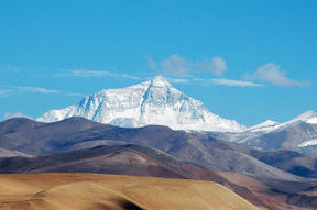
| photo_caption = {{small|Xiamángmú's north face from the Mirarian plateau}} | | photo_caption = {{small|Xiamángmú's north face from the Central Mirarian plateau}} | ||
| elevation_m = 8789 | | elevation_m = 8789 | ||
| elevation_ref = | | elevation_ref = | ||
Revision as of 17:58, 22 November 2015
| Xiamángmú | |
|---|---|
 Xiamángmú's north face from the Central Mirarian plateau | |
| Highest point | |
| Elevation | 8,789 m (28,835 ft) |
| Prominence | 8,789 m (28,835 ft) |
| Listing | Eight-thousander Country high point |
| Geography | |
| Location | Ghusao Prefecture, Temay; Harbes, Eliposi |
| Parent range | "Miralayas" |
Xiamangmu (Temay: Xia máng-mú /ɕiə˩ maŋ˩˥ mu˥/), also known in Elipa as x and in Zindarr as y, is Sahar's highest mountain. It is located in the Miralaya mountain range in Temau. Its peak is 8,789 metres (28,835 ft) above sea level. The international border between Eliposi and Temay runs across Xiamangmu's summit.