Difference between revisions of "Xynderland"
m |
(head section) |
||
| (2 intermediate revisions by the same user not shown) | |||
| Line 25: | Line 25: | ||
|capital = Dukrone<!--Name of country/territory's capital, wikilinked if link exists--> | |capital = Dukrone<!--Name of country/territory's capital, wikilinked if link exists--> | ||
|latd= | latm= | latNS= |longd= |longm= |longEW= <!--capital's latitude and longitude in degrees/minutes/direction--> | |latd= | latm= | latNS= |longd= |longm= |longEW= <!--capital's latitude and longitude in degrees/minutes/direction--> | ||
|largest_city = | |largest_city = capital | ||
|largest_settlement_type = | |largest_settlement_type = largest city | ||
|largest_settlement = <!--Name of largest settlement--> | |largest_settlement = <!--Name of largest settlement--> | ||
|official_languages = Xynder<!--Languages recognised in legislation, constitution, etc--> | |official_languages = Xynder<!--Languages recognised in legislation, constitution, etc--> | ||
| Line 39: | Line 39: | ||
|ethnic_groups = <!--List/breakdown of ethnic groups within the country/territory--> | |ethnic_groups = <!--List/breakdown of ethnic groups within the country/territory--> | ||
|ethnic_groups_year = <!--Year of ethnic groups data (if provided) or use to place a <ref>--> | |ethnic_groups_year = <!--Year of ethnic groups data (if provided) or use to place a <ref>--> | ||
|demonym = Xynden | |demonym = Xynden <!--Term/s describing those associated with the country/territory (e.g. "Belgian" for the country Belgium)--> | ||
|government_type = Unitary parliamentary constitutional republic <!--(often a compound multi-wikilinked term, e.g. "Federal semi-presidential constitutional republic", etc)--> | |||
|government_type = Unitary parliamentary constitutional republic <!--(often a compound multi-wikilinked term, e.g. "Federal semi-presidential constitutional republic", etc)--> | |leader_title1 = President<!--(for a country, usually the head of state's (wikilinked) title, e.g. "President", "Monarch")--> | ||
|leader_title1 = President<!--(for a country, usually the head of state's (wikilinked) title, e.g. "President", "Monarch")--> | |leader_name1 = Krystianen Primevus Kröaning | ||
|leader_name1 = Krystianen Primevus Kröaning | |||
|leader_title2 = <!--(could be "Vice President", otherwise "Prime Minster", etc, etc)--> | |leader_title2 = <!--(could be "Vice President", otherwise "Prime Minster", etc, etc)--> | ||
|leader_name2 = | |leader_name2 = | ||
| Line 64: | Line 63: | ||
|area_magnitude = | |area_magnitude = | ||
|area = <!--Major area size (in [[Template:convert]] either km2 or sqmi first)--> | |area = <!--Major area size (in [[Template:convert]] either km2 or sqmi first)--> | ||
|area_km2 = 59210<!--Major area size (in square km)--> | |area_km2 = 59210 <!--Major area size (in square km)--> | ||
|area_sq_mi = <!--Area in square mi (requires area_km2)--> | |area_sq_mi = <!--Area in square mi (requires area_km2)--> | ||
|area_footnote = <!--Optional footnote for area--> | |area_footnote = <!--Optional footnote for area--> | ||
|percent_water = 4.2 | |percent_water = 4.2 | ||
|area_label = | |area_label = Total | ||
|area_label2 = <!--Label below area_label (optional)--> | |area_label2 = <!--Label below area_label (optional)--> | ||
|area_data2 = <!--Text after area_label2 (optional)--> | |area_data2 = <!--Text after area_label2 (optional)--> | ||
|population_estimate = | |population_estimate = 14,009,086 | ||
|population_estimate_rank = | |population_estimate_rank = | ||
|population_estimate_year = | |population_estimate_year = | ||
| Line 97: | Line 96: | ||
|HDI_rank = | |HDI_rank = | ||
|HDI_year = | |HDI_year = | ||
|currency = | |currency = [[Forian acre]] <!--Name/s of currency/ies used in country/territory--> | ||
|currency_code = | |currency_code = FAA <!--ISO 4217 code/s for currency/ies (each usually three capital letters)--> | ||
|time_zone = | |time_zone = Forian Standard Time <!--e.g. GMT, PST, AST, etc, etc (wikilinked if possible)--> | ||
|utc_offset = + | |utc_offset = +0<!--in the form "+N", where N is number of hours offset--> | ||
|time_zone_DST = <!--Link to DST (Daylight Saving Time) used, otherwise "not observed"--> | |time_zone_DST = <!--Link to DST (Daylight Saving Time) used, otherwise "not observed"--> | ||
|utc_offset_DST = <!--in the form "+N", where N is number of hours offset--> | |utc_offset_DST = <!--in the form "+N", where N is number of hours offset--> | ||
|DST_note = <!--Optional note regarding DST use--> | |DST_note = <!--Optional note regarding DST use--> | ||
|antipodes = <!--Place/s exactly on the opposite side of the world to country/territory--> | |antipodes = <!--Place/s exactly on the opposite side of the world to country/territory--> | ||
|date_format = | |date_format = dd-mm-yyyy ([[Iovist calendar|Avi]]) | ||
|drives_on = left<!--"right" or "left" (side of road)--> | |drives_on = left <!--"right" or "left" (side of road)--> | ||
|cctld = <!--Internet country code top-level domain identifier (e.g. [[.br]], [[.de]], etc) | |cctld = <!--Internet country code top-level domain identifier (e.g. [[.br]], [[.de]], etc) | ||
|iso3166code = <!--Use to override default from common_name parameter above; omit using "omit".--> | |iso3166code = <!--Use to override default from common_name parameter above; omit using "omit".--> | ||
|calling_code = +22 <!--e.g. [[+1]], [[+531]], [[+44]], etc--> | |calling_code = +22 <!--e.g. [[+1]], [[+531]], [[+44]], etc--> | ||
|image_map3 = <!--Optional third map position, e.g. for use with reference to footnotes below it--> | |image_map3 = <!--Optional third map position, e.g. for use with reference to footnotes below it--> | ||
|alt_map3 = <!--alt text for third map position--> | |alt_map3 = <!--alt text for third map position--> | ||
| Line 120: | Line 119: | ||
}} | }} | ||
'''Xynderland''' ( | '''Xynderland''' ({{small|[[Xynder]]:}} ''Avxyntvälla'' [[Help:IPA_for_Xynder|/ˈäu̯zɪntˌvælːä/]]), officially the '''Republic of Xynderland''', is a sovereign state and an island country in [[Soltenna]]. Spanning (area), the country comprises the Xynden Isles, a small archipelago on the mouth of the [[Amiyant Sea]] dominated by the two islands of [[Xynden Island]] and [[Seret]]. Xynderland is bordered by [[Lugida]], (Zaizung) and [[Riyana]]. | ||
<!-- | |||
Evidence of modern humans inhabiting the Xynden Isles were dated back to as far as 30,000{{nbsp}}BCE. <!-- date subject to change --> [[Rietic languages|Rietic-speaking tribes]], ancestors to present day Xyndens, first inhabited the Xynden Island on around 1,800{{nbsp}}BCE. They founded Rietic settlements, characterized by its central city tree ([[hvoir]]), and founded the earliest known kingdoms in the island. | |||
==Etymology== | ==Etymology== | ||
==History== | ==History== | ||
===Early history=== | |||
Rietic peoples started to inhabit the Xynden Isles on around 2000 BCE, around the time when the (Name) Culture flourished. | |||
===Chiefdoms era=== | |||
===Antiquity=== | |||
===Forian era=== | |||
===Modern era=== | |||
<!-- Xynderland's independent history stretches back to 916, when the Kingdom of Xynderland seceded from Laefevia (or the Kingdom thereof), following the rise of a prominent king, namely King Thorin Dyring. The separation followed a Xynderian resistance which the Laefevian forces did not like and attempted to put down; though at the time, Laefevia had many other issues at hand and overlooked the secession of Xynderland. The Kingdom was then ruled under the Dyring Royal Family for the following 700 years. | <!-- Xynderland's independent history stretches back to 916, when the Kingdom of Xynderland seceded from Laefevia (or the Kingdom thereof), following the rise of a prominent king, namely King Thorin Dyring. The separation followed a Xynderian resistance which the Laefevian forces did not like and attempted to put down; though at the time, Laefevia had many other issues at hand and overlooked the secession of Xynderland. The Kingdom was then ruled under the Dyring Royal Family for the following 700 years. | ||
Revision as of 07:51, 15 July 2019
| Republic of Xynderland Öftregelnasan Avxyntvälsz
Öftregelnasan Avxyntvälś |
||||
|---|---|---|---|---|
|
||||
| Anthem: Svonie Jyrenne' | ||||
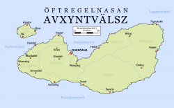
The map of Xynderland (Xynder)
|
||||
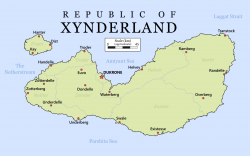
The map of Xynderland (English)
|
||||
| Capital and largest city | Dukrone | |||
| Official languages | Xynder | |||
| Recognised regional languages | Heufdalian, Exgot, Undren | |||
| Demonym | Xynden | |||
| Government | Unitary parliamentary constitutional republic | |||
| - | President | Krystianen Primevus Kröaning | ||
| Area | ||||
| - | Total | 59,210 km2 22,861 sq mi |
||
| - | Water (%) | 4.2 | ||
| Population | ||||
| - | estimate | 14,009,086 | ||
| - | Density | 236.6/km2 612.8/sq mi |
||
| HDI | 0.762 high |
|||
| Currency | Forian acre (FAA) | |||
| Time zone | Forian Standard Time (SCT+0) | |||
| Date format | dd-mm-yyyy (Avi) | |||
| Drives on the | left | |||
| Calling code | +22 | |||
Xynderland (Xynder: Avxyntvälla /ˈäu̯zɪntˌvælːä/), officially the Republic of Xynderland, is a sovereign state and an island country in Soltenna. Spanning (area), the country comprises the Xynden Isles, a small archipelago on the mouth of the Amiyant Sea dominated by the two islands of Xynden Island and Seret. Xynderland is bordered by Lugida, (Zaizung) and Riyana.
Evidence of modern humans inhabiting the Xynden Isles were dated back to as far as 30,000 BCE. Rietic-speaking tribes, ancestors to present day Xyndens, first inhabited the Xynden Island on around 1,800 BCE. They founded Rietic settlements, characterized by its central city tree (hvoir), and founded the earliest known kingdoms in the island.
Etymology
History
Early history
Rietic peoples started to inhabit the Xynden Isles on around 2000 BCE, around the time when the (Name) Culture flourished.
Chiefdoms era
Antiquity
Forian era
Modern era
Geography
Geology
Climate
Biodiversity
Politics
Government
Administrative divisions
Foreign relations
Military
Economy
Transport
Energy
Science and technology
Tourism
Demographics
Ethnic groups
Urbanisation
Language
Education
Healthcare
Religion
Culture
City trees
City trees (Xynder: Hvöiren, IPA: [ˈθvøɪɾ-ɛn]) are usually big and very old trees found in or near to the centre of most cities in Xynderland. It is said that the type of tree can say a lot about its city's people and past. A few centuries ago, they contained the honour and pride of a city, and was usually what brought the city together for festivals and other communal events. Quite far in history they even used to be worshipped and were seen as protectors of a city. During Xynderland's kingdom days, part of the punishment of treason was to have the city tree of the offender's home cut down, both as a symbol of power and to assure shame and dishonour towards the individual. When the Revolution happened, the city tree of the contemporary capital Euvo was cut down and called "corrupt" to reflect the opinions towards the then-dead king. Nowadays they are still heavily respected by the inhabitants, and are commonly seen a symbol of respect for those who have passed away.
Most city trees will possess a fairly large preserved area around them of empty field, serving as a reminder of the Xyndens' strong and historical connection with the beauty of nature even prior to urbanisation. Most city children will often gladly enjoy their time outside by the tree. The large area provides great opportunities for gatherings and most Xynden will get married under the tree before the city's people. Thus most people within a Xynderian city are very close and get along just as well as those who live in the countryside.
The trees' heart-warming significance means that in the rare cases they do get destroyed such as during heavy storms, it warrants the mourning of the entire city and even calls for national silence at times. Being seen attempting to destroy or deface the tree will in most occurrences result in one's immediate arrest. If somehow one manages to destroy a city tree without yet being apprehended, they are in accordance with historical law charged with treason. Despite this, the punishment for treason no longer has changed to exclude death and the felling of one's home-tree. This protectiveness of the trees seen in Xynden often confuses those not native to the culture.


