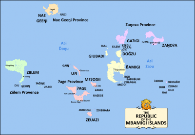
Provinces of the Republic of the Mbamigi Islands
Jump to navigation
Jump to search
The Republic of the Mbamigi Islands is divided into five provinces and one territory. Each province includes several islands. The Ndoone 'Age Capital Territory and 'Age Province are the only national subdivsions to share a land border as both are located on the island of 'Age.
All of Mbamigi's provinces are named after its largest or most populous island.
| Province | Flag | Area (km2) (sq mi) | Population | Population Density |
|---|---|---|---|---|
| Mbamigi Province |  |
9,767.44 km2 (3,771.23 sq mi) | 136,998 | 14.03/km2 (36.3/sq mi) |
| Ndoone 'Age Capital Territory |  |
177.22 km2 (68.43 sq mi) | 412,123 | 2,325.52/km2 (6,023.1/sq mi) |
| Ziilem Provence |  |
9,126.21 km2 (3,523.65 sq mi) | 11,188 | 1.23/km2 (3.2/sq mi) |
| Zango'a Province |  |
7,241.71 km2 (2,796.04 sq mi) | 135,095 | 18.66/km2 (48.3/sq mi) |
| Nae Geengi Province |  |
3,834.13 km2 (1,480.37 sq mi) | 7,520 | 1.96/km2 (5.1/sq mi) |
| 'Age Province |  |
7,395.52 km2 (2,855.43 sq mi) | 178,141 | 24.09/km2 (62.4/sq mi) |
| Total | 37,542.22 km2 (14,495.13 sq mi) | 881,065 | 23.47/km2 (60.8/sq mi) | |
