Difference between revisions of "Xiamangmu"
Jump to navigation
Jump to search
m |
|||
| (18 intermediate revisions by 6 users not shown) | |||
| Line 1: | Line 1: | ||
{{Infobox mountain | {{Infobox mountain | ||
| name = | | name = Xiamangmu | ||
| other_name = | | other_name = | ||
| photo = Xiamangmu.jpg | | photo = Xiamangmu.jpg | ||
| photo_size = 320px | | photo_size = 320px | ||
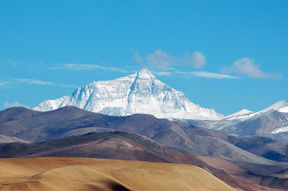
| photo_caption = {{small| | | photo_caption = {{small|Xiamangmu's north face from the Central Mirarian plateau}} | ||
| elevation_m = 8789 | | elevation_m = 8789 | ||
| elevation_ref = | | elevation_ref = | ||
| Line 11: | Line 11: | ||
| map = | | map = | ||
| map_caption = | | map_caption = | ||
| label = | | label = Xiamangmu | ||
| label_position = left | | label_position = left | ||
| listing = [[Eight-thousander]]<br/>[[List of countries by highest point|Country high point]] | | listing = [[Eight-thousander]]<br/>[[List of countries by highest point|Country high point]] | ||
| location = [[ | | location = [[Ghusau District]], [[Temay]] | ||
| range = [[Miralayas]] | |||
| first_ascent = 14 August 1942<br>[[Móit Falalüst]] and [[Eskumrád Enídbrád]]<br>[[1942 Barradiwan Xiamangmu expedition|(1942 Barradiwan Xiamangmu expedition)]] | |||
| normal_route = | | normal_route = | ||
}} | }} | ||
'''Xiamangmu''' ( | '''Xiamangmu''' ([[Temay language|Temay]]: ''Xiamaang-mu'' [[Temay language#Phonology|[ɕiə.maŋ.mu]]]) is [[Sahar]]'s [[List of highest mountains|highest mountain]]. It is located in the [[Miralayas|Miralayan]] mountain range, and its peak reaches {{convert|8789|m|ft|0}} above sea level. The international border between [[???]] and [[Temay]] runs across Xiamangmu's summit. | ||
[[Category:Temay]][[Category: | [[Category:Temay]] | ||
[[Category:Mountains]] | |||
[[Category:Geography of Parshita]] | |||
Latest revision as of 16:57, 26 June 2021
| Xiamangmu | |
|---|---|
 Xiamangmu's north face from the Central Mirarian plateau | |
| Highest point | |
| Elevation | 8,789 m (28,835 ft) |
| Prominence | 8,789 m (28,835 ft) |
| Listing | Eight-thousander Country high point |
| Geography | |
| Location | Ghusau District, Temay |
| Parent range | Miralayas |
| Climbing | |
| First ascent | 14 August 1942 Móit Falalüst and Eskumrád Enídbrád (1942 Barradiwan Xiamangmu expedition) |
Xiamangmu (Temay: Xiamaang-mu [ɕiə.maŋ.mu]) is Sahar's highest mountain. It is located in the Miralayan mountain range, and its peak reaches 8,789 metres (28,835 ft) above sea level. The international border between ??? and Temay runs across Xiamangmu's summit.