Difference between revisions of "Archive:Imoztar"
Jonnyboi 17 (talk | contribs) |
Jonnyboi 17 (talk | contribs) |
||
| Line 10: | Line 10: | ||
|alt_coat = <!--alt text for coat of arms--> | |alt_coat = <!--alt text for coat of arms--> | ||
|symbol_type = <!--emblem, seal, etc (if not a coat of arms)--> | |symbol_type = <!--emblem, seal, etc (if not a coat of arms)--> | ||
|national_motto = By God We Move | |national_motto = Jankteha Bozgibin (By God We Move) | ||
|national_anthem = <!--in italics (double quotemarks) and wikilinked if link exists--> | |national_anthem = <!--in italics (double quotemarks) and wikilinked if link exists--> | ||
|royal_anthem = <!--in italics (double quotemarks) and wikilinked if link exists--> | |royal_anthem = <!--in italics (double quotemarks) and wikilinked if link exists--> | ||
| Line 23: | Line 23: | ||
|capital = Eşniki | |capital = Eşniki | ||
|latd= | latm= | latNS= |longd= |longm= |longEW= <!--capital's latitude and longitude in degrees/minutes/direction--> | |latd= | latm= | latNS= |longd= |longm= |longEW= <!--capital's latitude and longitude in degrees/minutes/direction--> | ||
|largest_city = <!--Name of country/territory's largest city. Use "capital" (without quotemarks) if it's the capital.--> | |largest_city = Hatslénki <!--Name of country/territory's largest city. Use "capital" (without quotemarks) if it's the capital.--> | ||
|largest_settlement_type = <!--Type of settlement if largest settlement not a city--> | |largest_settlement_type = <!--Type of settlement if largest settlement not a city--> | ||
|largest_settlement = <!--Name of largest settlement--> | |largest_settlement = <!--Name of largest settlement--> | ||
| Line 68: | Line 68: | ||
|area_label2 = <!--Label below area_label (optional)--> | |area_label2 = <!--Label below area_label (optional)--> | ||
|area_data2 = <!--Text after area_label2 (optional)--> | |area_data2 = <!--Text after area_label2 (optional)--> | ||
|population_estimate = | |population_estimate = 41,800,000 | ||
|population_estimate_rank = | |population_estimate_rank = | ||
|population_estimate_year = | |population_estimate_year = 2015 | ||
|population_census = | |population_census = | ||
|population_census_year = | |population_census_year = | ||
|population_density_km2 = | |population_density_km2 = 9 | ||
|population_density_sq_mi = | |population_density_sq_mi = | ||
|population_density_rank = | |population_density_rank = | ||
| Line 94: | Line 94: | ||
|HDI_rank = | |HDI_rank = | ||
|HDI_year = | |HDI_year = | ||
|currency = <!--Name/s of currency/ies used in country/territory--> | |currency = Addza<!--Name/s of currency/ies used in country/territory--> | ||
|currency_code = <!--ISO 4217 code/s for currency/ies (each usually three capital letters)--> | |currency_code = ADZ<!--ISO 4217 code/s for currency/ies (each usually three capital letters)--> | ||
|time_zone = <!--e.g. GMT, PST, AST, etc, etc (wikilinked if possible)--> | |time_zone = <!--e.g. GMT, PST, AST, etc, etc (wikilinked if possible)--> | ||
|utc_offset = <!--in the form "+N", where N is number of hours offset--> | |utc_offset = <!--in the form "+N", where N is number of hours offset--> | ||
| Line 104: | Line 104: | ||
|date_format = <!--numeric dates (dd-mm-yyyy, yyyy.mm.dd, etc) plus era (CE, AD, AH, etc)--> | |date_format = <!--numeric dates (dd-mm-yyyy, yyyy.mm.dd, etc) plus era (CE, AD, AH, etc)--> | ||
|drives_on = <!--"right" or "left" (side of road)--> right | |drives_on = <!--"right" or "left" (side of road)--> right | ||
|cctld = <!--Internet country code top-level domain identifier (e.g. [[.br]], [[.de]], etc) | |cctld = .ir<!--Internet country code top-level domain identifier (e.g. [[.br]], [[.de]], etc) | ||
|iso3166code = <!--Use to override default from common_name parameter above; omit using "omit".--> | |iso3166code = <!--Use to override default from common_name parameter above; omit using "omit".--> | ||
|calling_code = <!--e.g. [[+1]], [[+531]], [[+44]], etc--> | |calling_code = <!--e.g. [[+1]], [[+531]], [[+44]], etc--> | ||
Revision as of 22:56, 31 August 2020
| Holy Republic of Imoztar Imoztori /imostɑri/ |
||||
|---|---|---|---|---|
|
||||
| Motto: Jankteha Bozgibin (By God We Move) | ||||
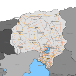
Roadmap of Imoztar
|
||||
| Capital | Eşniki | |||
| Largest | Hatslénki | |||
| Official languages | Imojan | |||
| Demonym | Imoztari | |||
| Government | ||||
| - | Sultan | Gostel Meznaharam | ||
| - | Prime Minister | Gostel Meznaharam | ||
| Population | ||||
| - | 2015 estimate | 41,800,000 | ||
| - | Density | 9/km2 23.3/sq mi |
||
| Currency | Addza (ADZ) | |||
| Drives on the | right | |||
| Internet TLD | .ir | |||
Imoztar (Imojan: Imoztor [imostɑr]), officially the Holy Republic of Imoztar, is a country located on the northern border of Lake Melkanchuta in the region of Vaniu.
Etymology
The common origin for the name of the Imoztar comes from the PWV word *ymmoz*, which means “heaven”, and *tɔɾi, which means “land”, which created the word *ymmoztɔɾi, “heaven’s land”.
History
The history of Imoztar starts off with the many people groups that used to live in the steppe around Lake Melkanchuta and Lake Mepteccis. These people lived off of the harsh desert land, raising livestock and surviving in oasis communities. Many of these groups were captured by (name of empire here) and many fled northwards towards present-day (name of mountain ranges on Northern border). Almost half of Imoztar was part of the Great Horde, and over 87% of the countries inhabitants claim heritage to the (GH ethnicity) ethnicity.
Geography
Imoztar is overall located in a cold desert climate, which is similar to a steppe climate. Without modern innovations and technologies, most of the country’s population would have to be situated around the lakes in order to survive.

