Difference between revisions of "Archive:Ngutan"
(→Geography: things) |
(Add some data to infobox) |
||
| Line 51: | Line 51: | ||
|area_km2 = 575491.54 | |area_km2 = 575491.54 | ||
|area_sq_mi = 222198.53 | |area_sq_mi = 222198.53 | ||
| | |percent_water = 8.44 | ||
|area_label = Total | |||
|area_label = | |||
|area_label2 = <!--Label below area_label (optional)--> | |area_label2 = <!--Label below area_label (optional)--> | ||
|area_data2 = <!--Text after area_label2 (optional)--> | |area_data2 = <!--Text after area_label2 (optional)--> | ||
| Line 84: | Line 83: | ||
|currency = <!--Name/s of currency/ies used in country/territory--> | |currency = <!--Name/s of currency/ies used in country/territory--> | ||
|currency_code = <!--ISO 4217 code/s for currency/ies (each usually three capital letters)--> | |currency_code = <!--ISO 4217 code/s for currency/ies (each usually three capital letters)--> | ||
|time_zone = Ngutan Time (SCT - | |time_zone = Ngutan Time (SCT -4) | ||
|utc_offset = - | |utc_offset = -4 | ||
|date_format = dd-mm-yyyy CE | |date_format = dd-mm-yyyy CE | ||
|drives_on = right | |drives_on = right | ||
| Line 91: | Line 90: | ||
|iso3166code = <!--Use to override default from common_name parameter above; omit using "omit".--> | |iso3166code = <!--Use to override default from common_name parameter above; omit using "omit".--> | ||
|calling_code = +32 | |calling_code = +32 | ||
}} | }} | ||
Revision as of 20:51, 6 October 2017
| The Republic of Ngutan Ngutānēha |
||||
|---|---|---|---|---|
|
||||
| Motto: "Ngaiwo se Ngutan!" "Ngutan forever!" |
||||
| Anthem: "Tāitāe Ngutānēho" "The Shout of Ngutan" |
||||
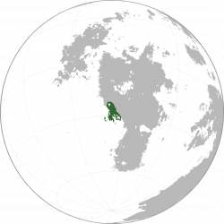
Location of Ngutan in Sahar
|
||||
| Official languages | Ngutanese | |||
| Demonym | Ngutanese | |||
| Area | ||||
| - | Total | 575,491.54 km2 222,198.53 sq mi |
||
| - | Water (%) | 8.44 | ||
| Population | ||||
| - | 2015 census | 6,899,576 | ||
| - | Density | 11.989/km2 4.629/sq mi |
||
| Time zone | Ngutan Time (SCT -4) (SCT-4) | |||
| Date format | dd-mm-yyyy CE | |||
| Drives on the | right | |||
| Calling code | +32 | |||
| Internet TLD | .ng | |||
Ngutan (Ngutanese: Ngutānēha [ŋu.taː'neː.hã]), officially the Republic of Ngutan, is a country located in the southern border of Upper Boroso, bordering Mekaneli to the north, Vaamek to the east, Mwamba to the southeast, and the Asura Ocean to the west. At 575,491 km2 (222,198 sq. mi), Ngutan is the ??th largest country in the world by area and has a population of six million people.
History
WIP
Prehistory
The first Ngutan people, known as Pre-Ngutanese, are presumed to have emigrated from Nagu, and pushing out the Proto-Upper-Borosans already located there.
Geography
At 575,491 km2 (222,198 sq. mi), Ngutan is the world's ??th largest country and Boroso's ??-th largest country. The territory of Ngutan is mostly included in the Ngutanese Peninsula and a few islands in the Asura Ocean. It lies between latitudes -35°N and -22°N, and longitudes -72°W and -61°W.
Geology
WIP
Climate
WIP
Biodiversity
WIP
Politics
WIP
Government
WIP
Administrative divisions
WIP
Foreign relations
WIP
Military
WIP
Economy
WIP
Transport
WIP
Energy
WIP
Science and technology
WIP
Tourism
WIP
Demographics
WIP
Ethnic groups
WIP
Urbanisation
WIP
Language
WIP
Education
WIP
Healthcare
WIP
Religion
WIP
Culture
WIP
Heritage
WIP
Architecture
WIP
Literature
WIP
Art
WIP
Music
WIP
Theatre
WIP
Film
WIP
Cuisine
WIP
Sport
WIP
Symbols
WIP
See also
WIP

