Difference between revisions of "Archive:Ngutan"
(→Demographics: ayy) |
(→Demographics: add Education) |
||
| Line 154: | Line 154: | ||
The Ngutanese society is quite homogeneous, composed of 96.3% ethnic Ngutanese, with the remaining being various immigrants from other countries, mainly from Boroso. | The Ngutanese society is quite homogeneous, composed of 96.3% ethnic Ngutanese, with the remaining being various immigrants from other countries, mainly from Boroso. | ||
===Urbanisation=== | ===Urbanisation=== | ||
| Line 165: | Line 162: | ||
===Education=== | ===Education=== | ||
Education in Ngutan is a mix of public and private schools, and it is compulsory from the ages five to seventeen. | |||
===Healthcare=== | ===Healthcare=== | ||
Revision as of 02:49, 16 October 2017
| The Republic of Ngutan Ngutānēha |
||||
|---|---|---|---|---|
|
||||
| Motto: "Ngaiwo se Ngutan!" "Ngutan forever!" |
||||
| Anthem: "Tāitāe Ngutānēho" "The Shout of Ngutan" |
||||
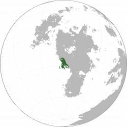
Location of Ngutan in Sahar
|
||||
| Official languages | Ngutanese | |||
| Demonym | Ngutanese | |||
| Area | ||||
| - | Total | 575,491.54 km2 222,198.53 sq mi |
||
| - | Water (%) | 8.44 | ||
| Population | ||||
| - | 2015 census | 23,019,700 | ||
| - | Density | 40/km2 15.444/sq mi |
||
| Time zone | Ngutan Time (SCT -4) (SCT-4) | |||
| Date format | dd-mm-yyyy CE | |||
| Drives on the | right | |||
| Calling code | +32 | |||
| Internet TLD | .ng | |||
Ngutan (Ngutanese: Ngutānēha [ŋu.taː'neː.hã]), officially the Republic of Ngutan, is a country located in the southern border of Upper Boroso, bordering Mekaneli to the north, Vaamek to the east, Mwamba to the southeast, and the Asura Ocean to the west. At 575,491 km2 (222,198 sq. mi), Ngutan is the ??th largest country in the world by area and has a population of 23 million people.
History
WIP
Prehistory
The first Ngutan people, known as Pre-Ngutanese, are presumed to have emigrated from Nagu, and pushing out the Proto-Upper-Borosans already located there.
Geography
At 575,491 km2 (222,198 sq. mi), Ngutan is the world's ??th largest country and Boroso's ??th largest country. The territory of Ngutan is mostly included in the Ngutanese Peninsula and a few islands in the Asura Ocean. It lies between latitudes -35°N and -22°N, and longitudes -72°W and -61°W.
Geology
Ngutanese's geology is quite varied. Most of the country sits atop the Ngutanese Plateau, ranging from 500 meters to 1500 meters high, with most of the mountains located in the south-central area of the peninsula or in the extreme north at the border with Mekaneli. The eastern part of the country is an exception to that; it is not on top of the plateau, but instead is filled with lakes, including the major Lake Aipoa, clocking in at 18,088.65 km2 of area. The north and northwestern part of the country are composed of flat or rolling hills with rocky formations.
Climate
Ngutan has a somewhat varied climate, that can be subdivided into three zones:
- The cold desert climate (BWk), predominant in the northern, northwestern and central areas, where the Ngutanese Desert is located. It is characterised by hot, dry summers and cold, dry winters. This area has a lot less people compared to the wetter areas.
- The cold semi-arid climate (BSk), covering a band in the central area of the country serving as a divide between the desert and the wetter areas. It is characterized by warm, dry summers and cold, wet winters, with exceptional wetness in spring and autumn.
- The warm-summer mediterranean climate (CSb), predominant in the south and southeast of the country. It is characterized by warm (but not hot), dry summers, with wet, cold winters. Most people live in this area.
There is also a thin area of hot desert climate (BWh) in the extreme north of the country almost at the border with Mekaneli, but in most cases that area can be ignored due to its small size and that there are very few people living there.
Biodiversity
WIP
Politics
WIP
Government
WIP
Administrative divisions
WIP
Foreign relations
WIP
Military
WIP
Economy
WIP
Transport
WIP
Energy
WIP
Science and technology
WIP
Tourism
WIP
Demographics
Ngutan's population is 23,019,700 as determined by the 2015 census, with a population density of exactly 40/km² (15.444/sq mi). The distribution of people accross the country is rather unequal, due to climate and historical constraints; most people inhabit the areas of the south and southeast where the climate is more pleasant.
The Ngutanese society is quite homogeneous, composed of 96.3% ethnic Ngutanese, with the remaining being various immigrants from other countries, mainly from Boroso.
Urbanisation
WIP
Language
The official language of Ngutan is Ngutanese, and more than 99% of people speak it as their first language, and not being able to speak Ngutanese is illegal if you are living in Ngutan. Ngutanese is a fusional language with a peculiar morphosyntactic alignment called the Austronesian alignment, which distinguishes the language from any other in Sahar.
Education
Education in Ngutan is a mix of public and private schools, and it is compulsory from the ages five to seventeen.
Healthcare
WIP
Religion
The vast majority of people follow Warisuism, or no religion at all.
Culture
WIP
Heritage
WIP
Architecture
WIP
Literature
WIP
Art
WIP
Music
WIP
Theatre
WIP
Film
WIP
Cuisine
WIP
Sport
WIP
Symbols
WIP
See also
WIP

