Difference between revisions of "Archive:Uvanga"
Jump to navigation
Jump to search
(Updated area and population) |
(Added locator map) |
||
| Line 15: | Line 15: | ||
|other_symbol_type = <!--Use if a further symbol exists, e.g. hymn--> | |other_symbol_type = <!--Use if a further symbol exists, e.g. hymn--> | ||
|other_symbol = | |other_symbol = | ||
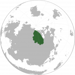
|image_map = <!--e.g. LocationCountry.svg--> | |image_map = Uvanga locator.png<!--e.g. LocationCountry.svg--> | ||
|alt_map = <!--alt text for map--> | |alt_map = <!--alt text for map--> | ||
|map_caption = <!--Caption to place below map--> | |map_caption = Location of Uvanga (green)<!--Caption to place below map--> | ||
|image_map2 = <!--Another map, if required--> | |image_map2 = <!--Another map, if required--> | ||
|alt_map2 = <!--alt text for second map--> | |alt_map2 = <!--alt text for second map--> | ||
Revision as of 04:50, 17 June 2017
| Uvanga Umampa |
||||
|---|---|---|---|---|
|
||||
Location of Uvanga (green)
|
||||
| Capital | Yksiö | |||
| Official languages | Thuun | |||
| Area | ||||
| - | 3,052,922 km2 1,178,740 sq mi |
|||
| Population | ||||
| - | (2015) estimate | 308,000 | ||
| - | Density | 0.101/km2 0.3/sq mi |
||
Uvanga (IPA: /uvɑŋɐ/, Thuun: Umampa, IPA: /ʉmɑmpɑ/), is a country located in north-eastern Miraria, bordering Achiyitqana to the east and Eliposi to the south-east.

