Difference between revisions of "Ikrem Mountains"
Jump to navigation
Jump to search
| Line 67: | Line 67: | ||
[[Category:Soltenna]] | [[Category:Soltenna]] | ||
[[Category:Mountains]] | [[Category:Mountains]] | ||
[[Category:Qgam]] | |||
Revision as of 01:35, 20 August 2017
| Ikrem Mountains | |
|---|---|
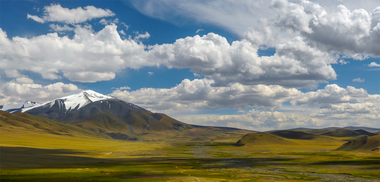
 Som Hmir Raw, the highest peak of the Ikrem Mountains. | |
| Highest point | |
| Peak | Som Hmir Raw (Šmuoy Kruo, Qgam) |
| Elevation | 4,193 m (13,757 ft) |
| Coordinates | Lua error in Module:Coordinates at line 492: attempt to index field 'wikibase' (a nil value). |
| Geography | |
| Countries | Template:Country data Chalyl and |
| continent | Soltenna |
The Ikrem Mountains are a mountain range in northwestern Soltenna. They stretch from the Khim Peninsula in Chalyl to Sĝkii Ldzaa in eastern Qgam. The Ikrems are not an an especially high mountain range, their highest peak being Som Hmir Raw, which reaches 4,193 metres (13,757 feet). The origin of its name is ultimately unknown, though it is believed to have derived from a Nuar language.
Geology
The Ikrem mountains are a very ancient mountain range, thought to have been formed some 1.1 billion years ago in the [Proterozoic Era]. The mountains are of such an age that all volcanic and seismic activity are now entirely nonexistent.