Difference between revisions of "Mount Metni"
Jump to navigation
Jump to search
m |
|||
| Line 67: | Line 67: | ||
==See also== | ==See also== | ||
[[Category:Volcanoes]] | |||
[[Category:Lugida]] | [[Category:Lugida]] | ||
[[Category:Kadya]] | [[Category:Kadya]] | ||
Revision as of 09:18, 31 July 2022
| Mount Metni | |
|---|---|
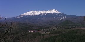
 Mount Metni seen from near the village of Analot | |
| Highest point | |
| Elevation | 3,595 m (11,795 ft) |
| Parent peak | Mount Yedn |
| Listing | Soltenna Major 10 |
| Coordinates | 40°12'N, 0°6'E |
| Naming | |
| Translation | "Cold rock" (Melune) |
| Geography | |
| Location | Metni Prefecture, Lugida Såra Province, Kadya |
| Parent range | Rietic Mountains |
| Geology | |
| Mountain type | Stratovolcano |
| Last eruption | 2000 |
Mount Metni (Lithian: Arad Metni) is an active stratovolcano in northern Rietic Mountains, located on the border of Lugida and Kadya. At 3,595 metres (11,795 ft)* above sea level, it is the highest mountain in Kadya, and the highest volcano in Lugida after Mount Lenthir.