Difference between revisions of "Yezeip"
(Created page with "{{Infobox settlement | name = Yezeip | native_name = Yezɨip | native_name_lang = <!-- ISO 639-2 code e.g. "fr" for French. If more than one, use {{lang}} instead --> | settlement_type = Capital city | image_skyline = | image_alt = | image_caption = | image_flag = | flag_alt = | image_seal = | seal_alt = | image_shield...") |
|||
| (4 intermediate revisions by the same user not shown) | |||
| Line 4: | Line 4: | ||
| native_name_lang = <!-- ISO 639-2 code e.g. "fr" for French. If more than one, use {{lang}} instead --> | | native_name_lang = <!-- ISO 639-2 code e.g. "fr" for French. If more than one, use {{lang}} instead --> | ||
| settlement_type = Capital city | | settlement_type = Capital city | ||
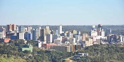
| image_skyline = | | image_skyline = Yezeip skyline.jpg | ||
| image_alt = | | image_alt = | ||
| image_caption = | | image_caption = | ||
| image_flag = | | image_flag = | ||
| Line 83: | Line 83: | ||
| population_as_of = 2023 | | population_as_of = 2023 | ||
| population_footnotes = | | population_footnotes = | ||
| population_total = | | population_total = 1,503,013 | ||
| population_density_km2 = auto | | population_density_km2 = auto | ||
| population_note = | | population_note = | ||
| Line 100: | Line 100: | ||
}} | }} | ||
'''Yezeip''' (pronunciation: // <!--add IPA in the native language, and any other minority languages in the city-->) is the capital of [[Ogtop]]. <!--add the settlement's location within its native country/island/continent; add a brief summary of anything important and interesting related to the settlement--> | '''Yezeip''' (pronunciation: // <!--add IPA in the native language, and any other minority languages in the city-->) is the capital of [[Ogtop]]. Is situated in north east of the country alongside of the river OOO. It is the house and the seat of the governament of the country. <!--add the settlement's location within its native country/island/continent; add a brief summary of anything important and interesting related to the settlement--> | ||
==Etymology== | ==Etymology== | ||
==History== | ==History== | ||
===Construction and development=== | |||
When Ogtop got its indipendece [[Moibaku]] was declared national capital. In 1961 [[Palhapato Auku]] designed appointed a group of experts to find the best place for the capital city with particular emphasis on location, climate, logistics, and defence requirements. After extensive study, research, and a thorough review of potential sites, the commission recommended the area in northeast near to the old capital but more covered from external attacks, especially from a continuous fear that [[Asesha]] would attack the nation. Moreover the new city was connected to the river OOO which led to a much-needed economic expansion of the fledgling country. | |||
In 1961 [[Balak people|Balak]] architects were hired, lead by [[BALAK NAME]] to plan the city according to the disposition of the tribes of the population of Ogtop. According to the census of the 1891, made by the Aseshan Governament, there were 14 Ogtop tribes, 9 [[Magura]] tribes and 10 [[Sawe]] tribes, therefore they created one district for each tribe per ethnicity to rapresent the union of the country. At that time not all of the ethicies were included, because the cencus were putdated and not precise even in the late 19th century. This lead to create last district in 1968 to rapresent the other minoreties. | |||
The capital was not moved directly from Moibaku to Yezeip; the governament first decleard both of the country capitals in the 1964, and then all the powers were shifted to Yezeip when essential development work was completed in 1966. In 1970, the capital became an autonomous in its own [[Yezeip Capital Territory| special province]]. | |||
===Controversies=== | |||
==Geography== | ==Geography== | ||
Latest revision as of 15:52, 28 December 2023
Yezeip
Yezɨip | |
|---|---|
Capital city | |
 | |
| Country | Ogtop |
| Population (2023) | |
| • Total | 1,503,013 |
Yezeip (pronunciation: // ) is the capital of Ogtop. Is situated in north east of the country alongside of the river OOO. It is the house and the seat of the governament of the country.
Etymology
History
Construction and development
When Ogtop got its indipendece Moibaku was declared national capital. In 1961 Palhapato Auku designed appointed a group of experts to find the best place for the capital city with particular emphasis on location, climate, logistics, and defence requirements. After extensive study, research, and a thorough review of potential sites, the commission recommended the area in northeast near to the old capital but more covered from external attacks, especially from a continuous fear that Asesha would attack the nation. Moreover the new city was connected to the river OOO which led to a much-needed economic expansion of the fledgling country.
In 1961 Balak architects were hired, lead by BALAK NAME to plan the city according to the disposition of the tribes of the population of Ogtop. According to the census of the 1891, made by the Aseshan Governament, there were 14 Ogtop tribes, 9 Magura tribes and 10 Sawe tribes, therefore they created one district for each tribe per ethnicity to rapresent the union of the country. At that time not all of the ethicies were included, because the cencus were putdated and not precise even in the late 19th century. This lead to create last district in 1968 to rapresent the other minoreties.
The capital was not moved directly from Moibaku to Yezeip; the governament first decleard both of the country capitals in the 1964, and then all the powers were shifted to Yezeip when essential development work was completed in 1966. In 1970, the capital became an autonomous in its own special province.