File:Gfw map districts with railways, stations and ferry line stations.png
Jump to navigation
Jump to search


Size of this preview: 641 × 599 pixels. Other resolution: 950 × 888 pixels.
Original file (950 × 888 pixels, file size: 181 KB, MIME type: image/png)
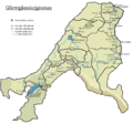
Map of Gfiewish states with altitude levels and all still existing railway lines and stations (excluding additional stops in larger towns such as Hatariew) as well as towns and villages served by ferry lines.
File history
Click on a date/time to view the file as it appeared at that time.
| Date/Time | Thumbnail | Dimensions | User | Comment | |
|---|---|---|---|---|---|
| current | 14:44, 26 June 2021 |  | 950 × 888 (181 KB) | Jute (talk | contribs) | Map of Gfiewish states with altitude levels and all still existing railway lines and stations (excluding additional stops in larger towns such as Hatariew) as well as towns and villages served by ferry lines. Category:Maps of Ystel [[Category:Rail... |
You cannot overwrite this file.
File usage
There are no pages that use this file.