Thewer River
| Thewer River | |
|---|---|
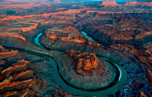
 The Bends stretch of the Thewer River. | |
 Thewer River Basin. | |
| Other name(s) | |
| Etymology | From Proto-Theweric *Siwīɣ "great centre" |
| Basin | |
| River system | Thewer |
| River mouth | Lake Qeerles |
| Countries | |
| Physiognomy | |
| Length | 1,348.95 km (838.20 mi) |
The Thewer River is a large river in Upper Boroso. The Thewer starts in the Fydor Highlands in Thewer, and travels southwest to drain into Lake Qeerles, forming a land border of Lhavres. Senqet, the largest canyon on Sahar, forms 446 km (277 mi) of the border.
The Thewer drains an expansive, arid watershed that encompasses parts of Thewer, Lhavres, Tuanmali, and a small bit of Taanttu. Beginning in the Fydor Highlands, the river flows generally southwest across the Qeerlic Plateau and through the Senqet Canyon before emptying into Lake Qeerles.
Etymology
The term Thewer comes from Proto-Theweric *Siwīɣ, a compound of siw-gīɣ "great centre." It is of the same etymological origin as Dhwer.
History
The Thewer has always been important in the history of Upper Boroso. As the largest navigable river in the north of the continent, trade occurred along the river and into the Borosan Great Lakes.
Course
Watershed
Fauna
Geology
Tributaries
[[Category:Rivers in Boroso]