Difference between revisions of "Archive:Vemou"
| Line 90: | Line 90: | ||
|Gini_rank = | |Gini_rank = | ||
|Gini_year = | |Gini_year = | ||
|HDI = 0. | |HDI = 0.862 | ||
|HDI_ref = <!--(for any ref/s to associate with HDI number)--> | |HDI_ref = <!--(for any ref/s to associate with HDI number)--> | ||
|HDI_rank = | |HDI_rank = | ||
Revision as of 00:05, 20 February 2016
| The Free Association of Viunze Le Asociacion Frie de Viunze |
||||
|---|---|---|---|---|
|
||||
| Motto: In mase, ve fioren. Together, we flourish. |
||||
| Anthem: Le sain deus såsses The Song of the Willows |
||||
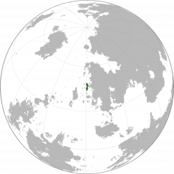
Location of Viunze on Sahar
|
||||
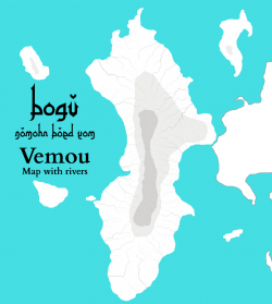
Map of Viunze with major cities
|
||||
| Capital | Sausseveu | |||
| Largest | Férsai | |||
| Official languages | Illaine | |||
| Recognised regional languages | Ammaric | |||
| Government | Free association | |||
| Establishment | ||||
| - | Independence from Mettat; establishment of the Viunze Republic | 1957 | ||
| - | Breakup of the Viunze Republic; establishment of the Free Association | 2014 | ||
| Population | ||||
| - | 2015 census | 10,929,091 | ||
| - | Density | 109.1/km2 282.6/sq mi |
||
| GDP (nominal) | 2015 estimate | |||
| - | Total | $209.565 billion | ||
| - | Per capita | $19,175 | ||
| HDI (2015) | 0.862 very high |
|||
| Currency | Corone (VCR) | |||
| Time zone | WST (SCT-1) | |||
| Drives on the | right | |||
| Internet TLD | .vz | |||
Viunze (IPA: /vi.ˈʌnz/, Illaine: Viunze, IPA: /vjunz/), officially the Free Association of Viunze, is a country located on the island of Vetes. It is separated to the east from Ammia and mainland Miraria by the Rude Strait, and shares sea borders with Laefevia to the south, Ohkoria to the west, and Mettat to the north. It is a protectorate of the Union of Šarkunen Nations.
Etymology
The name Viunze comes from the Ancient Methinat spoken by the Mettat Empire in ancient times. The Ancient Methinat name was "wêtis-udənstám", meaning "Willow Island", named for either the island's widespread Salix atrocinerea plants or the alpine Salix lanata. This later became simplified to "wétunstam", then "wéuntsa", then "wiunza". This, in turn, was later adapted into Illaine as "Viunze".
History
Prehistory
The areas currently controlled by Viunze were populated by nomadic times in ancient times. Artifacts of early settlements have been found and dated to as far back as 3700 BCE. The language of these tribes, called Albian, was related to Ancient Methinat. Their language greatly influenced Illaine.
Methinat Rule
In the mid-first century, sometime between 1800 BC and 1700 BC, the Kingdom of Mettat took control of the region. Ancient Methinat became the predominant language, which is reflected in the fact that many place names have been derived from Ancient Methinat. One prominent example of this is Férsai.
Outside Influence
Between 200 BCE and 300 CE, Dansc tribes, who were related to the Thythisc, moved into the area. They intermingled with the Albians, and the area became a melting pot of cultures. Over time, the Methinat culture was ousted, and a mix of Vulgar Albian and Old Dansc became the predominant language, which eventually developed into Illaine. However, the area remained controlled by Mettat until May 1857.
Viunze Independence
In May 1857, Viunze gained its independence from Mettat via referendum. Consequently, the Viunze Republic was established.
Viunze Republic
Viunze was a democratic republic from May 1857 until July 2014. In March 2013, the economy collapsed, and inflation began to increase exponentially. By October 2013, the Viunze Coroné was worth practically nothing, with the exchange rate cr¤15 264,48 = US$1.
Coup d'etat
In July 2014, the Viunze Lynx Party staged a coup d'etat. With the widespread support of the public, they were able to take over the government without the use of violence. The government was dissolved, the Constitution of Viunze was written, and the congress was replaced with the Viunze Ting, which was only given the power deal with foreign policy and enforce the Constitution. A free association system was put into place.
Geography

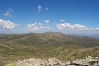
Mont Néfe is the highest point in Viunze, with a height of 2,174 metres (7,133 ft).
Viunze lies between latitudes 34° and 41° N, and longitudes 14° W and 21° W.
To the south, Viunze shares a sea border with Ohkoria and Sanpo; on the north, it shares a sea border with Mettat; and to the east, it shares a border with Ammia along the Rude Strait.
Islands
Other than the main island of Vetes, Viunze has five islands. They are, from largest to smallest, Quéte, to the northeast; Acunze, to the northwest; Euvunze, to the southwest; Taque-deus-Dracons, to the southeast; and Férsiette just off the western coast.
Mountains
The Serre Mountains run vertically through the centre of Viunze. The tallest peaks are Mont Néfe (2,174 metres (7,133 ft)), Mont Péndre (2,146 metres (7,041 ft)), and Mont Corre (2,061 metres (6,762 ft)).


