Difference between revisions of "Lhavres"
| Line 95: | Line 95: | ||
|GDP_nominal_per_capita = $57,433 | |GDP_nominal_per_capita = $57,433 | ||
|GDP_nominal_per_capita_rank = | |GDP_nominal_per_capita_rank = | ||
|Gini = | |Gini = 45 | ||
|Gini_ref = <!--(for any ref/s to associate with Gini number)--> | |Gini_ref = <!--(for any ref/s to associate with Gini number)--> | ||
|Gini_rank = | |Gini_rank = | ||
Revision as of 13:30, 26 November 2015
| The Federal Republic of Lhavres Lhavrëšnhë (Kavrinian) Lyaanrazga (Czucz) Wààprësknà (Setyalnian) |
||||||
|---|---|---|---|---|---|---|
|
||||||
| Motto: "Taak lïz teek czukzänoeks!" "We soar far and wide!" |
||||||
| Anthem: "Konaa Uksitlhäšnevuus" "The Grand Mountain, Konaa" |
||||||
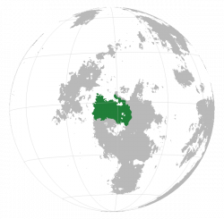
Location of Lhavres on Sahar.
|
||||||
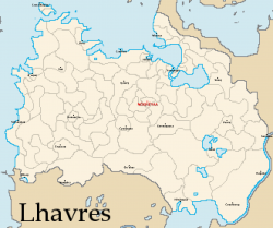
A map of Lhavres showing provincial borders and key cities.
|
||||||
| Capital | Noekzrëyaa | |||||
| Largest | Yaakzeksyë | |||||
| Official languages | Kavrinian Czucz Setyalnian |
|||||
| Recognised regional languages | Ahaksian Riisian Nuhzäyin Vuurušnian |
|||||
| Ethnic groups | 31.9% Konaacz 24.8% Lhaviin 16.4% Setyals 9.1% Czucz 4.3% Vuuruš 13.5% Other |
|||||
| Demonym | Lhavrinian | |||||
| Government | Federal representative democratic republic | |||||
| - | Ruling Body | Hsaanelhotoeš Congress | ||||
| Independent | ||||||
| - | Konaaczinh tribes begin forming jointly-controlled colonial chiefdoms | c. 4500 BCE | ||||
| - | The Czucz Empire rises and expands along the northern coastline | c. 1450 BCE | ||||
| - | The Konaaczinh Lhav tribe begins to unite the tribes around Mount Konaa, eventually forming the Lhav Empire | c. 552 BCE | ||||
| - | The Lhav Empire collapses due to increasingly ineffective rule | c. 50 CE | ||||
| - | The Kav tribe, led by Hsunhatošlhë, unites all inhabited regions of Konaaczëšnhë and Czuczëšnhë | 227 | ||||
| - | The Republic of Kavrinia merges with the Kingdom of Dhwer to form the Grand Union of Dhwer-Kavrinia | 1089 | ||||
| - | The GUDK collapses due to internal struggles | 1271 | ||||
| - | Lhavres defeats the Dhwer Empire and gains control of Yaakzëšnhë | c. 1730 | ||||
| - | Lhavres conquers the Setyal Empire, attaining its modern borders | 1844 | ||||
| Area | ||||||
| - | 3,493,712 km2 (3rd) 1,348,930 sq mi |
|||||
| Population | ||||||
| - | 2015 census | 172,981,063 | ||||
| - | Density | 49.5/km2 128/sq mi |
||||
| GDP (PPP) | 2015 estimate | |||||
| - | Total | $8.9 trillion | ||||
| - | Per capita | $51,454 | ||||
| GDP (nominal) | 2015 estimate | |||||
| - | Total | $9.934 trillion | ||||
| - | Per capita | $57,433 | ||||
| Gini (2015) | 45 medium |
|||||
| HDI (2015) | 0.86 very high |
|||||
| Currency | Lhavrinian kzeštukz (LHA) | |||||
| Time zone | West Lhavres Time (SCT -4) East Lhavres Time (SCT -3) |
|||||
| Date format | mm-dd-yyyy CE | |||||
| Drives on the | right | |||||
| Calling code | +34 | |||||
| Internet TLD | .lh | |||||
Lhavres (IPA: /lɑvɹes/, Kavrinian: Lhavrëšnhë, IPA: /ʟɑvrəʃŋə/), officially the Federal Republic of Lhavres, is a country located in northern Boroso, occupying much of the continent's geographic northwest region. It neighbors Dhwer and Vaamek to its east, and Vrkhazia to its south. The nation is multispecies in makeup and was built on the systems and ideals set in place by the native avian Kavrinhäk peoples, who founded the nation in its current form back in 227 CE. Due to human migration and integration however, the population is 57% human and 41% Kavrinh, with the remaining 2% being made up of other species from around Sahar (the largest of these minority populations being Fals and Daolchúlla). The nation is known for having several popular tourist destinations found throughout the entire country.
Etymology
The native name, Lhavrëšnhë, which becomes Lhavres in anglicization for convenience, comes from Kavrinian and means "land of Lhavs". The Lhavs were a Konaaczinh tribe that formed an ancient empire in what is now western Lhavres, known as the Lhav Empire. The empire fell sometime around 50 CE but the region became united again less than two centuries later by the Lhavs's sister tribe, the Kavs (whose name gave us the current common name for the Kavrinhäk), who brought all known inhabited lands in the region under one banner through charisma and promises of prosperity. After the split from Dhwer in 1271, the land chose "Lhavrëšnhë" "land of Lhavs" as its name.
History
Geography
The nation's geography is diverse, featuring vast rainforests, wetlands, savannas, steppes, and desert.


