Difference between revisions of "Manatak Autonomous Territory"
Jump to navigation
Jump to search
Total pleb (talk | contribs) m |
Total pleb (talk | contribs) m |
||
| Line 12: | Line 12: | ||
| shield_size = 75px | | shield_size = 75px | ||
| anthem = | | anthem = | ||
| image_map = MAT | | image_map = Locator map MAT.png | ||
| map_caption = | | map_caption = | ||
| coordinates = | | coordinates = | ||
Revision as of 00:07, 29 January 2021
Manatak Autonomous Territory
TBD (Balak) TBD (Ziimen) | |
|---|---|
Coat of arms of Manatak Autonomous Territory Coat of arms | |
 | |
| Country | |
| Capital | Şarandah |
| Government | |
| • Body | Manatak Territorial Parliament |
| • State President | TBD |
| • Council of Elders votes | 4 (of 66) |
| • Common Council seats | 55 (of 1,345) |
| Population (2016) | |
| • Total | 2,757,613 |
| Official languages | Balak; (one of the Ziimen langs) |
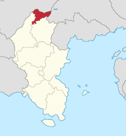
The Manatak Autonomous Territory (Balak: TBD), informally known as Manachik (Balak: Manaçik Manaçik [ˌmɑnɑˈt͡ʃɪk]) and abbreviated as MAT (Balak: TBD), is a landlocked state of Balakia, bordering the states of Tarashik and Kazan, as well as the countries of Torosha and Amaia. Its capital is Şarandah. The MAT is the Xth largest of Balakia's 15 federal subjects, and the tenth most populous, with over 2.5 million inhabitants.
Etymology
History
Geography
Demographics
Culture
See also
 |
( |

| ||
| ( | ||||
| ||||

