Difference between revisions of "Mehyaran"
| (7 intermediate revisions by 2 users not shown) | |||
| Line 1: | Line 1: | ||
{{OOD}} | |||
{{Infobox settlement | {{Infobox settlement | ||
| name = Mehyaran | | name = Mehyaran | ||
| Line 16: | Line 17: | ||
| nickname = | | nickname = | ||
| motto = | | motto = | ||
| image_map = | | image_map = Mehyara Locator.png | ||
| map_alt = | | map_alt = A map of Tabiqa showing Mehyarāsa Province and Mehyaran Metro Area | ||
| map_caption = | | map_caption = Mehyaran Metro Area within [[Mehyarāsa]] Province | ||
| pushpin_map = | | pushpin_map = | ||
| pushpin_label_position = | | pushpin_label_position = | ||
| Line 30: | Line 31: | ||
| subdivision_type = Country | | subdivision_type = Country | ||
| subdivision_name = [[Tabiqa]] | | subdivision_name = [[Tabiqa]] | ||
| subdivision_type1 = | | subdivision_type1 = Province | ||
| subdivision_name1 = | | subdivision_name1 = Mehyarāsa | ||
| subdivision_type2 = | | subdivision_type2 = | ||
| subdivision_name2 = | | subdivision_name2 = | ||
| Line 37: | Line 38: | ||
| subdivision_name3 = | | subdivision_name3 = | ||
| established_title = | | established_title = | ||
| established_date = | | established_date = c. 8000 BCE | ||
| founder = | | founder = | ||
| seat_type = | | seat_type = | ||
| Line 43: | Line 44: | ||
| government_footnotes = | | government_footnotes = | ||
| leader_party = | | leader_party = | ||
| leader_title = | | leader_title = Tolyar | ||
| leader_name = Saona Vistat | | leader_name = Saona Vistat | ||
| unit_pref = Metric | | unit_pref = Metric | ||
| Line 83: | Line 84: | ||
| population_as_of = 2013 | | population_as_of = 2013 | ||
| population_footnotes = | | population_footnotes = | ||
| population_total = | | population_total = 4,161,320 | ||
| population_density_km2 = auto | | population_density_km2 = auto | ||
| population_note = | | population_note = | ||
| Line 100: | Line 101: | ||
}} | }} | ||
'''Mehyaran''' ([[Adzamasi]]: [mɛçɑʁɑŋ]) is the capital and most populous city of [[Tabiqa]]. It is located at the confluence of the [[Ekuos River]] and the [[Tabiq River]]. It is one of the oldest permanently-inhabited settlements on Sahar. | '''Mehyaran''' ([[Adzamasi]]: [mɛçɑʁɑŋ]) is the capital and most populous city of [[Tabiqa]] with over four million inhabitants. It is located at the confluence of the [[Ekuos River]] and the [[Tabiq River]], and its metro area encompasses land on all sides of the rivers as well as some of the islands within them. It is one of the oldest permanently-inhabited settlements on Sahar. | ||
==Etymology== | ==Etymology== | ||
Old Adzamian ''mehya-ran'' [mɛhjɐχɐn] ' | Old Adzamian ''mehya-ran'' [mɛhjɐχɐn] 'three rivers'. The name clearly refers to its location at the confluence of the [[Ekuos river|Ekuos]] and [[Tabiq river|Tabiq]] rivers, but there is debate as to whether the 'third' river is the combined river (a continuation of the Ekuos) or one of the smaller rivers located near the capital. Prime among these candidates is the Arak, which comes closest, and the now-dry Tulürao. | ||
In many historical texts Mehyaran is also known as Rekkanran (Old Adzamian [χɛk'ɐnʁən]) 'three cities.' | |||
==History== | ==History== | ||
Fossil records indicate early humans used | Fossil records indicate early humans used sites around East Mehyaran, probably as a trading post or seasonal pasture grounds, as early as BCE 41,000. Archaeological evidence indicates that permanent or seasonal dwellings existed in the region by BCE 18,600. It is difficult to place exactly when the urban area was first developed because many early buildings have been lost to seasonal flooding and erosion over the centuries. Many historians place the beginning of the city at around 7,100 BCE with the building of the [[Name bridge]] across the Tabiq river, the ruins of which can still be found north of the city. | ||
By BCE 1,000, Mehyaran was a centre of commerce for the Ekuosian desert, and a respectably-sized city. It served as the capital for the [[Adzamasi Empire]] which spread across much of north Baredina between BCE 500 and CE 700. After the fall of the empire, it was one of few areas to remain independent during the conquests of the Algadoran, Penaxxi and | By BCE 1,000, Mehyaran was a centre of commerce for the Ekuosian desert, and a respectably-sized city. It served as the capital for the [[Adzamasi Empire]] which spread across much of north Baredina between BCE 500 and CE 700. After the fall of the empire, it was one of few areas to remain independent during the conquests of the Algadoran, Penaxxi and Neviran empires, maintaining its government and laws through both military and diplomacy. | ||
It was re-established as the capital of modern Tabiqa in the 1700s. | It was re-established as the capital of modern Tabiqa in the 1700s. | ||
Due to the width of the Ekuos and Tabiq rivers, the city was originally three or more distinct urban areas which enjoyed a close relationship but distinctive governments and, to some extent, cultures. Buildings that were too close to the banks of the river collapsed or sunk and been swept away. There are a number of ruins along the eastern bank of the joined rivers showing early buildings that were too close to the river's edge. | |||
==Geography== | ==Geography== | ||
| Line 117: | Line 122: | ||
==Cityscape== | ==Cityscape== | ||
Important buildings in Mehyaran include the [[Tabiqan Parliament]] and [[Palace of Mehyaran]], the seat of the country's monarch. | |||
==Culture== | ==Culture== | ||
| Line 132: | Line 137: | ||
[[Category:Settlements | [[Category:Settlements]] [[Category:Capitals]] [[Category:Tabiqan settlements]] | ||
Latest revision as of 07:06, 17 January 2023
 | This article or section is out of date. A country/countries relevant to this article have been removed from Sahar and have been retconned. Not everything here may still be considered canonical. This article was last edited by Arryog (talk | contribs) 14 months ago. (Update) |
Mehyaran
Meśārāŋ | |
|---|---|
 | |
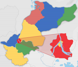
 Mehyaran Metro Area within Mehyarāsa Province | |
| Country | Tabiqa |
| Province | Mehyarāsa |
| Government | |
| • Tolyar | Saona Vistat |
| Population (2013) | |
| • Total | 4,161,320 |
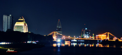
Mehyaran (Adzamasi: [mɛçɑʁɑŋ]) is the capital and most populous city of Tabiqa with over four million inhabitants. It is located at the confluence of the Ekuos River and the Tabiq River, and its metro area encompasses land on all sides of the rivers as well as some of the islands within them. It is one of the oldest permanently-inhabited settlements on Sahar.
Etymology
Old Adzamian mehya-ran [mɛhjɐχɐn] 'three rivers'. The name clearly refers to its location at the confluence of the Ekuos and Tabiq rivers, but there is debate as to whether the 'third' river is the combined river (a continuation of the Ekuos) or one of the smaller rivers located near the capital. Prime among these candidates is the Arak, which comes closest, and the now-dry Tulürao.
In many historical texts Mehyaran is also known as Rekkanran (Old Adzamian [χɛk'ɐnʁən]) 'three cities.'
History
Fossil records indicate early humans used sites around East Mehyaran, probably as a trading post or seasonal pasture grounds, as early as BCE 41,000. Archaeological evidence indicates that permanent or seasonal dwellings existed in the region by BCE 18,600. It is difficult to place exactly when the urban area was first developed because many early buildings have been lost to seasonal flooding and erosion over the centuries. Many historians place the beginning of the city at around 7,100 BCE with the building of the Name bridge across the Tabiq river, the ruins of which can still be found north of the city.
By BCE 1,000, Mehyaran was a centre of commerce for the Ekuosian desert, and a respectably-sized city. It served as the capital for the Adzamasi Empire which spread across much of north Baredina between BCE 500 and CE 700. After the fall of the empire, it was one of few areas to remain independent during the conquests of the Algadoran, Penaxxi and Neviran empires, maintaining its government and laws through both military and diplomacy.
It was re-established as the capital of modern Tabiqa in the 1700s.
Due to the width of the Ekuos and Tabiq rivers, the city was originally three or more distinct urban areas which enjoyed a close relationship but distinctive governments and, to some extent, cultures. Buildings that were too close to the banks of the river collapsed or sunk and been swept away. There are a number of ruins along the eastern bank of the joined rivers showing early buildings that were too close to the river's edge.
Geography
Climate
Cityscape
Important buildings in Mehyaran include the Tabiqan Parliament and Palace of Mehyaran, the seat of the country's monarch.