Isata
 | This article or section is out of date. A country/countries relevant to this article have been removed from Sahar and have been retconned. Not everything here may still be considered canonical. This article was last edited by Allwinter (talk | contribs) 8 months ago. (Update) |
| The Republic of Isata Lútha Ísata |
||||||
|---|---|---|---|---|---|---|
|
||||||
| Capital and | Sulu | |||||
| Official languages | Wahala | |||||
| Recognised national languages | wip | |||||
| Ethnic groups (2020) | Isatese | |||||
| Demonym | Isatese | |||||
| Government | unitary presidential republic | |||||
| - | Prime Minister | |||||
| Independence from Balak Empire in 1963 | ||||||
| Population | ||||||
| - | 2020 estimate | 22,640 | ||||
| Currency | Canamic Rhasa (R or $R) | |||||
| Date format | dd.mm.yyyy CE | |||||
| Drives on the | right | |||||
| Internet TLD | .isa | |||||
Isata (Wahala: Lútha Ísata [lu˥thɐ i˥sɐtɐ]), officially the Republic of Isata, is a country located in the Asura Ocean
Etymology
The etymology of the country is quite simple: "ísata" simply means land in Wahala. Because the Isatese explored very little and stayed on their islands, the only land they ever saw was their own islands.
History
Arrival at around 900 AD. First contact with Canana at around 1000 AD, first written records with Canana at 1050 AD. Cananas brought glassworking and their sun religion, which was partly adopted into their original faith. Contact with Milhidia in 1100 AD. Colonized by Canana in 1622. Athsud took control in DATE. Balakia conquered and merged the two islands into one political entity and made into a protectorate. Independence granted in 1963. Very rough history that is yet to be decided.
Geography
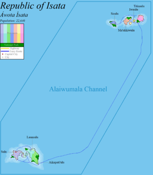
The Republic of Isata is an island nation that lies east of Milhidia and consists of 8 major islands and over 100 smaller islands in the Asura Ocean. The two archipelagos that make up the country are split in the middle by the equator running between them. The country boasts many volcanic high islands and numerous atolls. Mount Nhatuwa reaches 502 meters (1647 ft), making it the highest point of the country. Many atolls are scattered among the two archipelagos and very few people live on them, with the exception of the largest atoll: Upalai.
The country's islands lie between latitudes 2°N and 2°S, and longitudes 152° and 153°E. The distance between the north and south island chains is about NUMBER kilometers (NUMBER mi). The country is fairly isolated from the rest of the world, with its closest neighbor Milhidia being over NUMBER kilometers (NUMBER mi) away.
Geology
Climate
The islands' ocean-equatorial climate is extremely humid throughout the year, with an average temperature of 27°C (80.6°F). Though seasons are not really distinct, July through September is considered to be the cooler period. Tropical cyclones can hit during any part of the year but are more frequent December through April. Annual rainfall in Isata is about 4,200 millimeters (165 in).
Biodiversity
Politics
Government
Administrative divisions
The Republic of Isata is divided into seven different provinces between the two island chains. In the north there are the provinces of Sisulu, Ma'alikiwulu, Iwaulu, and Titimulu. In the south there are the provinces of Sulu, Laumulu, and Aikapati'ulu. Because the island country only has a population of 22,640 people, each province is named after the largest village within the region's borders.
Foreign relations
Military
Economy
Transport
In recent years the government has allocated more funds towards transportation projects. Construction on the newest freeway, the FR-7 (Federal Road #7), was finished in early 2018; connecting the towns of Laumulu and Aikapati'ulu on the Samahatila Island. The federal freeway system is considered unfinished and is unlikely to be finished without foreign investments. Only 1/4th of Isatese households own a car. The majority of locals travel by private boat or by the extensive federal ferry system.
There is only two airports in the country: the Kawiti International Airport and the recently completed Pilhai National Airport in the Ma'alikiwulu province.
Energy
Science and technology
lol
Tourism
Demographics
94% Isatese 6% Other


