Difference between revisions of "List of sovereign states and dependent territories in Nagu"
Jump to navigation
Jump to search
Quidditchhp (talk | contribs) |
|||
| (36 intermediate revisions by 17 users not shown) | |||
| Line 1: | Line 1: | ||
[[File:Nagu Locator.png|thumb|right| | [[File:Nagu Locator.png|thumb|right|300px|{{legend|#346733|Nagu}}]] | ||
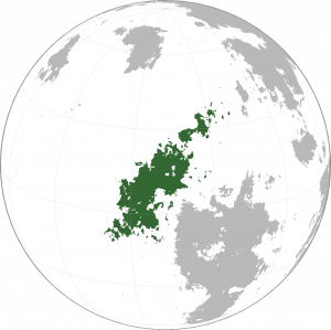
The list below entails all fully and partially recognized states and territories in [[Nagu]]. There are currently | The list below entails all fully and partially recognized states and territories in [[Nagu]], including the Naguan mainland as well as the Draconic islands. There are currently 9 fully recognized countries within Nagu and one dependency. | ||
==Countries and dependencies== | ==Countries and dependencies== | ||
===Recognized states=== | ===Recognized states=== | ||
| Line 20: | Line 17: | ||
! style="font-weight: bold;" | Notes | ! style="font-weight: bold;" | Notes | ||
|- | |- | ||
| [[File:Astalva Flag.png|100px|frameless|center]] | |||
| [[File: | |||
| <!-- map --> | | <!-- map --> | ||
| [[Astalva]]<br>Federation of Astalva and Associated Islands | | [[Astalva]]<br><small>Federation of Astalva and Associated Islands</small> | ||
| [[Zveahe]]: Astalva<br>P̃aitøspa hav Astalva x hav Aṽísí B̃atnena | | [[Zveahe]]: Astalva<br><small>P̃aitøspa hav Astalva x hav Aṽísí B̃atnena</small> | ||
| [[Velthal]] | | [[Velthal]] | ||
| | | 42,898,000 | ||
| <!-- {{convert|AREAKM2|km2|sqmi}} --> | | <!-- {{convert|AREAKM2|km2|sqmi}} --> | ||
| <!-- notes --> | | <!-- notes --> | ||
|- | |- | ||
| [[File: | | [[File:C&CBig.png|100px|frameless|center]] | ||
| <!-- map --> | | <!-- map --> | ||
| [[ | | [[Chelgyu and Chinamshi]]<br><small>The Confederation of the State of Chelgyu and the Kingdom of Chinamshi</small> | ||
| [[ | | [[Yandu language|Yandu]]: Xàul beh xéid gwa xȇid nạn xé, [[Cheli language|Cheli]]: Hyelhíçû cò Yahyásuçû <br><small></small> | ||
| [[ | | [[Nȃigón]], [[Nígukénçû]] | ||
| | | 6,673,619 | ||
| | | {{convert|115,193|km2|sqmi}} | ||
| <!-- notes --> | | <!-- notes --> | ||
|- | |- | ||
| [[File: | | [[File:Danshapu_flag.png|100px|frameless|center]] | ||
| <!-- map --> | | <!-- map --> | ||
| [[ | | [[Danshapu]]<br><small>Country of Danshapu</small> | ||
| [[ | | [[Danshali|Danshali]]: Danshapu <br> <small>Danshapuno Xisinmopu</small> | ||
| [[ | | [[Tayozepu]] | ||
| | | 11,037,398 | ||
| | | {{convert|105118.08|km2|sqmi}} | ||
| <!-- notes --> | | <!-- notes --> | ||
|- | |- | ||
| [[File: | | [[File:Tfianeng.svg|100px|frameless|center]] | ||
| <!-- map --> | | <!-- map --> | ||
| [[ | | [[Tfianeng]]<br><small>Republic of Tfianeng</small> | ||
| [[ | | [[Gheeitang language|Gheeitang]]: Tfianeng <br> <small>Gheredas khee Tfianeng</small> | ||
| [[ | | [[Diraḍinu]] | ||
| | | 73,191,882 | ||
| | | {{convert|405,009|km2|sqmi}} | ||
| <!-- notes --> | | <!-- notes --> | ||
|- | |||
|} | |} | ||
[[Category: | |||
[[Category:Nagu]][[Category:Countries in Nagu|*]][[Category:Continents]][[Category:Lists of countries]] | |||
Latest revision as of 01:02, 26 January 2024
The list below entails all fully and partially recognized states and territories in Nagu, including the Naguan mainland as well as the Draconic islands. There are currently 9 fully recognized countries within Nagu and one dependency.
Countries and dependencies
Recognized states
| Flag | Map | Short and formal names | Domestic short and formal names | Capital | Population | Area | Notes |
|---|---|---|---|---|---|---|---|
| Astalva Federation of Astalva and Associated Islands |
Zveahe: Astalva P̃aitøspa hav Astalva x hav Aṽísí B̃atnena |
Velthal | 42,898,000 | ||||
| Chelgyu and Chinamshi The Confederation of the State of Chelgyu and the Kingdom of Chinamshi |
Yandu: Xàul beh xéid gwa xȇid nạn xé, Cheli: Hyelhíçû cò Yahyásuçû |
Nȃigón, Nígukénçû | 6,673,619 | 115,193 square kilometres (44,476 sq mi) | |||
| Danshapu Country of Danshapu |
Danshali: Danshapu Danshapuno Xisinmopu |
Tayozepu | 11,037,398 | 105,118.08 square kilometres (40,586.32 sq mi) | |||
| Tfianeng Republic of Tfianeng |
Gheeitang: Tfianeng Gheredas khee Tfianeng |
Diraḍinu | 73,191,882 | 405,009 square kilometres (156,375 sq mi) |


