List of sovereign states and dependent territories in Boroso
 | |
| Countries | 8 (list of countries) |
|---|---|
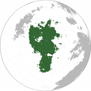
Boroso is a large continent located wholly within the Western Hemisphere and almost wholly within the Southern Hemisphere of Sahar. It is bordered to the east by the Taanttu Gulf (to the north) and the Armizziya Ocean (to the south), to the west by the Asura Ocean, and to the north by the Dragon Sea. The continent Nagu lies off Boroso's northwest coast.
Boroso covers an area of about 31,995,287 square kilometres (12,353,449 sq mi), about <something>% of Sahar's land area and about 6.25% of Sahar's total surface. It is the third continent by area, following Miraria and Baredina.
Regions
Boroso is commonly divided into two regions, Upper (North) Boroso and Lower (South) Boroso. The Isthmus of Katar, which divides the two halves, is entirely controlled by the Fals Empire.
Countries and dependencies
Boroso is divided into at least 9 countries.
Recognized states
| Flag | Country locator | Short and formal names | Domestic short and formal names | Capital | Population | Area | Notes |
|---|---|---|---|---|---|---|---|
| Fals Empire | Faljüdax: Kuulatir Fals | Ikolinis | 143,088,469 | ||||
Geography
The lake region of west-central Boroso is known as the Borosan Great Lakes and is thought to be the original homeland of the Barmeki ethnicity.
The names of the major lakes in Vaamekian are (from largest to smallest):
